
Votice
Votice | |
|---|---|
Town | |
 General view | |
 Flag  Coat of arms | |
 Votice Location in the Czech Republic | |
| Coordinates: 49°38′25″N 14°38′17″E / 49.64028°N 14.63806°E | |
| Country | |
| Region | Central Bohemian |
| District | Benešov |
| First mentioned | 1359 |
| Government | |
| • Mayor | Jiří Slavík |
| Area | |
| • Total | 36.4 km2 (14.1 sq mi) |
| Elevation | 483 m (1,585 ft) |
| Population (2020-01-01[1]) | |
| • Total | 4,569 |
| • Density | 130/km2 (330/sq mi) |
| Time zone | UTC+1 (CET) |
| • Summer (DST) | UTC+2 (CEST) |
| Postal code | 259 01 |
| Website | www |
Votice (Czech pronunciation: [ˈvocɪtsɛ]; German: Wotitz) is a town in Benešov District in the Central Bohemian Region of the Czech Republic. It has a population of about 4,600. There is a high hill named Mezivrata just south of the town.
History
The first mention of the town is in a document from 1359, however the archaelogic research showed that the town was probably established around year 1150.
Gallery
-
 The roundabout and the castle
 -
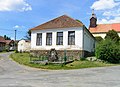 Old school in Martinice, part of Votice


References
- ^ "Population of Municipalities – 1 January 2020". Czech Statistical Office. 2020-04-30.
Wikimedia Commons has media related to Votice.
| International | |
|---|---|
| National | |