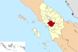
North Tapanuli Regency
North Tapanuli Regency
(Kabupaten Tapanuli Utara) | |
|---|---|
 | |
| Country | Indonesia |
| Province | North Sumatra |
| Regency seat | Tarutung |
| Government | |
| • Regent | Nikson Nababan |
| • Vice Regent | Sarlandy Hutabarat |
| • Chairman of Regency's Council of Representatives | Poltak Pakpahan (PDI-P) |
| • Vice Chairpeople of Regency's Council of Representatives | Fatimah Hutabarat (Nasdem) and Reguel Simanjuntak (Golkar) |
| Area | |
| • Total | 3,793.71 km2 (1,464.76 sq mi) |
| Population (2019)[1] | |
| • Total | 308,532 |
| • Density | 81/km2 (210/sq mi) |
| Time zone | UTC+7 (WIB) |
| Website | www |
North Tapanuli Regency (Tapanuli Utara - in Indonesian, "utara" means "north") is a regency in North Sumatra province, Sumatra, Indonesia. Its capital is Tarutung. The regency covers an area of 3,793.71 square kilometres and according to the 2010 census it had a population of 278,897;[2] the latest official estimate (for mid 2019) is 308,532.[3]
Administration
The regency is divided into fifteen districts (kecamatan), tabulated below with their areas and their 2010 Census population,[4] together with the estimated populations in mid 2017:[5] The table also includes the number of administrative villages (desa and kelurahan, 252 in total) in each district and its post code.
| Name | Area in km2 |
Pop'n Census 2010[4] |
Pop'n Estimate mid 2017[6] |
No. of vill. |
Post code |
|---|---|---|---|---|---|
| Parmonangan | 257.35 | 13,021 | 13,891 | 14 | 22453 |
| Adian Koting | 502.90 | 13,876 | 14,798 | 16 | 22461 |
| Sipoholon | 189.20 | 22,365 | 23,744 | 14 | 22452 |
| Tarutung | 107.68 | 39,500 | 42,125 | 31 | 22411 -22417 &22452 |
| Siatas Barita | 92.92 | 13,063 | 13,929 | 12 | 22417 -22419 |
| Pahae Julu | 165.90 | 11,740 | 12,529 | 19 | 22463 |
| Pahae Jae | 203.20 | 10,569 | 11,272 | 13 | 22465 |
| Purbatua | 191.804 | 7,164 | 7,641 | 11 | 22464 |
| Simangumban | 150.00 | 7,300 | 7,786 | 8 | 22466 |
| Pangaribuan | 459.25 | 26,751 | 28,514 | 26 | 22472 |
| Garoga | 567.58 | 15,581 | 16,614 | 13 | 22473 |
| Sipahutar | 408.22 | 24,536 | 26,169 | 25 | 22471 |
| Siborong-Borong | 279.91 | 44,170 | 47,098 | 21 | 22474 |
| Pagaran | 138.05 | 16,539 | 17,642 | 14 | 22458 |
| Muara | 79.75 | 13,182 | 14,054 | 15 | 22476 |
| Totals | 3,793.71 | 278,897 | 297,806 | 252 |
Soda Pond

Soda Pond, or Aek Rara is located at the bottom of Parbubu I Hill village. The pond's natural spring water generates bubbles and a soda aroma can be smelled. It is safe for swimming, but the use of googles is recommended. The locals regularly use the water from the pond to water nearby rice paddy fields.[7]
References
- ^ Badan Pusat Statistik, Jakarta, 2020.
- ^ Seta,William J. Atlas Lengkap Indonesia dan Dunia (untuk SD, SMP, SMU, dan Umum). Pustaka Widyatama. p. 9. ISBN 979-610-232-3.
- ^ Badan Pusat Statistik, Jakarta, 2020.
- ^ a b Biro Pusat Statistik, Jakarta, 2011.
- ^ Badan Pusat Statistik, Jakarta, 2020.
- ^ Badan Pusat Statistik, Jakarta, 2020.
- ^ "Aek Rara, Kolam Air Soda di Tarutung". April 14, 2012.


