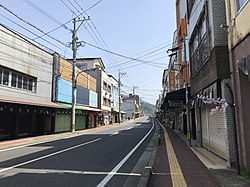
Kusu, Ōita
Appearance
This article needs additional citations for verification. (December 2009) |
Kusu
玖珠町 | |
|---|---|
Town | |
 Kusu Town | |
 Location of Kusu in Ōita Prefecture | |
| Coordinates: 33°17′N 131°9′E / 33.283°N 131.150°E | |
| Country | Japan |
| Region | Kyushu |
| Prefecture | Ōita Prefecture |
| District | Kusu |
| Government | |
| • Mayor | Masakazu Shukuri |
| Area | |
• Total | 286.44 km2 (110.60 sq mi) |
| Population (March 31, 2017) | |
• Total | 15,954 |
| • Density | 56/km2 (140/sq mi) |
| Time zone | UTC+09:00 (JST) |
| Website | www |
| Symbols | |
| Flower | Rhododendron japonicum |
| Tree | Camphor Japanese zelkova |
Kusu (玖珠町, Kusu-machi) is a town located in Kusu District, Ōita Prefecture, Japan.
As of March 2017, the town has an estimated population of 15,954.[1] The total area is 286.44 km².
Geography
Neighbouring municipalities
Transportation
Railways
Expressways
Notable people from Kusu
- Seishiro Etō, politician
- Kurushima Takehiko, former children's literature author
References
- ^ "Official website of Kusu town" (in Japanese). Japan: Kusu town. Archived from the original on 3 June 2010. Retrieved 21 April 2017.
External links
 Media related to Kusu, Ōita at Wikimedia Commons
- Kusu official website (in Japanese)


