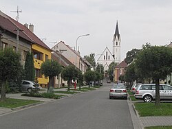
Dolní Němčí
Appearance
Dolní Němčí | |
|---|---|
 Church of Saints Philip and James | |
| Coordinates: 48°58′6″N 17°35′9″E / 48.96833°N 17.58583°E | |
| Country | |
| Region | Zlín |
| District | Uherské Hradiště |
| First mentioned | 1358 |
| Government | |
| • Mayor | František Hajdůch |
| Area | |
• Total | 9.91 km2 (3.83 sq mi) |
| Elevation | 256 m (840 ft) |
| Population (2020-01-01[1]) | |
• Total | 2,977 |
| • Density | 300/km2 (780/sq mi) |
| Time zone | UTC+1 (CET) |
| • Summer (DST) | UTC+2 (CEST) |
| Postal code | 687 62 |
| Website | www |
Dolní Němčí (until 1925 Dolněmčí) is a municipality and village in Uherské Hradiště District in the Zlín Region of the Czech Republic. It has about 3,000 inhabitants.
Dolní Němčí lies approximately 15 kilometres (9 mi) south-east of Uherské Hradiště, 30 km (19 mi) south of Zlín, and 290 km (180 mi) south-east of Prague.
Culture and sport
There are many ensembles including foklor group NK Dolněmčan and football clubs designated for all age groups ranging from small children up to adults. Gamekeeping also has a long tradition as in the whole Zlín Region.
Twin towns – sister cities
Dolní Němčí is twinned with:[2]
 Myjava, Slovakia
References
- ^ "Population of Municipalities – 1 January 2020". Czech Statistical Office. 2020-04-30.
- ^ "Hodnotiaca správa programového rozpočtu mesta Myjava k 31. 12. 2018" (PDF). myjava.sk (in Slovak). Myjava. p. 20 (53). Retrieved 2019-09-05.
External links
Wikimedia Commons has media related to Dolní Němčí.


