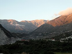
Dukat, Albania
Appearance
Dukat | |
|---|---|
 | |
| Coordinates: 40°15′2″N 19°34′2″E / 40.25056°N 19.56722°E | |
| Country | |
| County | Vlorë |
| Municipality | Vlorë |
| Municipal unit | Orikum |
| Time zone | UTC+1 (CET) |
| • Summer (DST) | UTC+2 (CEST) |
Dukat is a community of the Vlorë County, southern Albania. At the 2015 local government reform it became part of the municipality Vlorë.[1]
History
World War II
During World War II Dukat was part of the battlefield of the battle of Gjorm, where Albanian resistance units defeated and routed the troops of the Kingdom of Italy.[2]
Demographics
Dukat is mixed, inhabited 73% by Orthodox Christians and 21% by Muslims and the whole village speaks Albanian.[3] It is home to the Church of Marmiroi, a medieval church.
References
- ^ "Law nr. 115/2014" (PDF). Archived from the original (PDF) on 2015-09-24. Retrieved 2015-07-02.
- ^ Pearson, Owen (2006). Albania in Occupation and War: From Fascism to Communism 1940-1945. I.B.Tauris. p. 230. ISBN 1-84511-104-4.
- ^ Hammond, Nicholas Geoffrey Lemprière (1967). Epirus: the Geography, the Ancient Remains, the History and Topography of Epirus and Adjacent Areas. Oxford: Clarendon Press. p. 126.
{{cite book}}: Invalid|ref=harv(help) "Dukat, which is majority Christian and minority Mohammedan, but entirely Albanian in speech"
External links
![]() Media related to Dukat at Wikimedia Commons
Media related to Dukat at Wikimedia Commons


