Tårup
Appearance
Tårup | |
|---|---|
Village | |
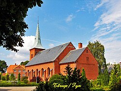
 Tårup Church | |
Location in the Region of Southern Denmark | |
| Coordinates: 55°14′07″N 10°46′22″E / 55.23528°N 10.77278°E | |
| Country | |
| Region | |
| Municipality | |
| Population (2020)[1] | 310 |
Tårup is a village in central Denmark, located in Nyborg municipality on the island of Funen in Region of Southern Denmark.
History
Tårup was first mentioned in 1361 as Thorpe. The name comes from the Danish word 'torp', translating to a settlement with a population from another village - in this case Frørup. Through the Middle Ages most of Tårup was owned by the crown.[2]
Tårup Church
Tårup Church is located in Tårup, and was built in 1883 by Jens Eckersberg. The church's current organ is from 2001. A model ship was bought during the church's 100-year anniversary in 1983. The ship is a model of a ship that sailed in the Great Belt Strait when the church was built in 1883. The two bells in the church are from the Netherlands and were built in 1972.[3]
References
- ^ BY3: Population 1 January, by urban areas The Mobile Statbank from Statistics Denmark
- ^ Taarupportalen.dk "Lokalhistorie" Retrieved 4 August 2020
- ^ Xn--frrup-trup-kirker-frb96a.dk "Tårup Kirke" Retrieved 4 August 2020


