Kallikrateia
Kallikrateia
Καλλικράτεια | |
|---|---|
Settlement | |
 View of Nea Kallikrateia | |
| Coordinates: 40°19′N 23°04′E / 40.317°N 23.067°E | |
| Country | Greece |
| Administrative region | Central Macedonia |
| Regional unit | Chalkidiki |
| Municipality | Nea Propontida |
| Area | |
| • Municipal unit | 108.9 km2 (42.0 sq mi) |
| Elevation | 20 m (70 ft) |
| Population (2011)[1] | |
| • Municipal unit | 11,571 |
| • Municipal unit density | 110/km2 (280/sq mi) |
| • Community | 7,238 |
| Time zone | UTC+2 (EET) |
| • Summer (DST) | UTC+3 (EEST) |
| Postal code | 63080 |
| Area code(s) | 2399 |
| Vehicle registration | ΧΚx-xxxx |
| Website | http://www.kallikrateia.gr |
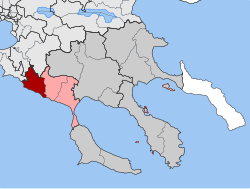
Kallikrateia (Template:Lang-el) is a municipal unit in Chalkidiki, Greece. Since the 2011 local government reform it is part of the municipality of Nea Propontida, before which it was a municipality with its seat in the town Nea Kallikrateia.[2] The municipal unit has an area of 108.894 km2.[3] According to the census of 2011, it has a population of 11,571 people. Nea Kallikrateia was established after the refugee crisis in 1922, mainly by the residents who came from Kallikrateia (today Mimarsinan) in Eastern Thrace and set up in the area, where the metohi of the Xenofontos Monastery of Mount Athos existed and it was called “Stomion”. Many testimonies report that it was inhabited by the prehistoric years; however, they are not confirmed.
Subdivisions
The municipal unit of Kallikrateia consists of the communities of Agios Pavlos, Lakkoma, Nea Gonia, Nea Kallikrateia and Nea Silata.
References
- ^ "Απογραφή Πληθυσμού - Κατοικιών 2011. ΜΟΝΙΜΟΣ Πληθυσμός" (in Greek). Hellenic Statistical Authority.
- ^ "EETAA local government changes". Retrieved 29 June 2020.
- ^ "Population & housing census 2001 (incl. area and average elevation)" (PDF) (in Greek). National Statistical Service of Greece. Archived from the original (PDF) on 2015-09-21.
External links
Kallikrateia.gr, a news portal based in Nea Kallikrateia: [1] (in Greek)


