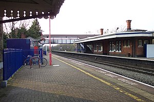
Tilehurst railway station
 Station buildings and footbridge | |||||
| General information | |||||
| Location | Tilehurst, Borough of Reading England | ||||
| Grid reference | SU674752 | ||||
| Managed by | Great Western Railway | ||||
| Platforms | 4 | ||||
| Other information | |||||
| Station code | TLH | ||||
| Classification | DfT category E | ||||
| History | |||||
| Opened | 1882 | ||||
| Original company | Great Western Railway | ||||
| Pre-grouping | GWR | ||||
| Post-grouping | GWR | ||||
| Passengers | |||||
| 2015/16 | |||||
| 2016/17 | |||||
| 2017/18 | |||||
| 2018/19 | |||||
| 2019/20 | |||||
| |||||


Tilehurst railway station is in the suburb and former village of Tilehurst, west of Reading, Berkshire, England. It is 38 miles 52 chains (62.2 km) down the line from London Paddington and is situated between Reading to the east and Pangbourne to the west.
The station is served by local services operated by Great Western Railway.
History
The station is on the original line of the Great Western Railway, which opened in 1841, and was itself opened to traffic in 1882.[1]
Description
Tilehurst station is on the extreme northern edge of the suburb of Tilehurst, and at a much lower level than most of that suburb. The railway line and station occupy a strip of land between the A329 road and the River Thames, with the up relief platform on an embankment above the river bank.
The station has four platforms, one on each of the fast and relief (slow) lines, although the platforms on the fast lines see little use except during track works on the line between Reading and Didcot. The platforms are linked to each other and the station entrance, on the down fast platform, by a footbridge.
There is a waiting room in the middle platform which contains separate Ladies and Gents toilets. A small waiting room was built on the north platform, but although it looks old, it is of modern construction.
The Main Ticket Office on the south side is manned usually on weekday mornings but tickets can also be purchased from an automatic machine using Debit or Credit Cards only.
In 2013 the redundant Goods Shed was demolished to make way for a new footbridge. The line from Paddington to Wales has been scheduled to be electrified and the old footbridge does not have enough clearance for the electric wires to be hung underneath.
The new Footbridge was opened in early December 2013 and the old footbridge demolished the following week. The footbridge does not have lifts so disabled people still have to climb the stairs to the platforms in normal use.
Services
Tilehurst station is mostly served by stopping services run by Great Western Railway between London Paddington and Didcot Parkway with some additional services on weekdays running between Reading and Oxford in the morning and evening peak times. The typical off-peak service is every 30 minutes in each direction Monday to Saturday and hourly on Sundays. Typical journey times are approximately 25 minutes to Didcot Parkway, 45 minutes to Oxford, 5 minutes to Reading, and just over 1 hour to London Paddington.[2]
| Preceding station | Following station | |||
|---|---|---|---|---|
| Pangbourne | Great Western Railway Commuter services Great Western Main Line |
Reading | ||
In literature
The railway at Tilehurst was mentioned in less than glowing terms by Jerome K. Jerome in chapter 16 of Three Men in a Boat: "The river becomes very lovely from a little above Reading. The railway rather spoils it near Tilehurst, but from Mapledurham up to Streatley it is glorious."[3]
References
- ^ Waters, Lawrence (1990). Rail Centres: Reading. Ian Allan Ltd. ISBN 0-7110-1937-1.
- ^ https://www.gwr.com/~/media/gwr/pdfs/timetables/2018/amended-june/t10,-d-,web-v2.pdf?la=en
- ^ Jerome, Jerome K. "Three Men in a Boat". Project Gutenberg. Retrieved 14 April 2007.
External links
- Train times and station information, from National Rail
