
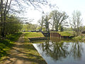
Sulhamstead Lock
Sulhamstead Lock is a lock on the River Kennet at Sulhamstead in the English county of Berkshire.
Sulhamstead Lock was built between 1718 and 1723 under the supervision of the engineer John Hore of Newbury, and this stretch of the river is now administered by the Canal & River Trust and known as the Kennet Navigation. It has a rise/fall of 4 ft 1 in (1.25 m).[1]
The lock was rebuilt in 1966 by a collaboration involving staff from British Waterways and volunteer labour.[2]
-
 Sulhampstead Lock
 -
 Sulhampstead Manually Operated Swing Bridge


References
- ^ Pearson, Michael (2003). Kennet & Avon Middle Thames:Pearson's Canal Companion. Rugby: Central Waterways Supplies. ISBN 0-907864-97-X.
- ^ "Kennet & Avon Canal". Inland Waterways Association. Retrieved 17 May 2011.
See also
51°25′25″N 1°05′07″W / 51.42364°N 1.08524°W
This article about a Berkshire building or structure is a stub. You can help Wikipedia by expanding it. |