
Kanavuori
Parts of this article (those related to population) need to be updated. (November 2020) |
You can help expand this article with text translated from the corresponding article in Finnish. (May 2015) Click [show] for important translation instructions.
|
Kanavuori | |
|---|---|
District of Jyväskylä | |
 Kanavuori | |
 | |
| Coordinates: 62°13′56″N 025°53′47″E / 62.23222°N 25.89639°E | |
| Country | |
| Region | Central Finland |
| Sub-region | Jyväskylä sub-region |
| City | Jyväskylä |
| Ward | Vaajakoski-Jyskä |
| Population (31 December 2007) | |
• Total | 738 |
| Time zone | UTC+2 (EET) |
| • Summer (DST) | UTC+3 (EEST) |
| Postal code | 40800 Vaajakoski |
Kanavuori is a district, a hill and a nature reserve in Jyväskylä, Finland. It is a part of Vaajakoski-Jyskä ward. It is located at around 10 kilometres (6 mi) from the city centre on the shores of Vaajavirta river between lake Päijänne and lake Leppävesi. There were 738 inhabitants on 31 December 2007.[1]
Gallery
-
 Haapakoski railway bridge
 -
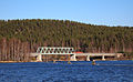
 Kanavuori seen from Vaajakoski
 -
 Vaajavirta and Koskenvuori hill


References
- ^ "Vaajakoski". 2010. Archived from the original on 17 December 2011. Retrieved 1 April 2012.
External links
 Media related to Kanavuori at Wikimedia Commons
- Armoria Training Centre – an indoor shooting range, firearm and safety sector training centre in Kanavuori
This Western Finland location article is a stub. You can help Wikipedia by expanding it. |