Eo (river)
Appearance
You can help expand this article with text translated from the corresponding article in Spanish. (April 2013) Click [show] for important translation instructions.
|
| Eo | |
|---|---|
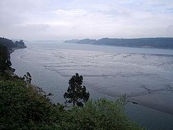
 View of Eo River, Ramsar Site | |
 | |
| Location | |
| Country | |
| Physical characteristics | |
| Source | |
| • location | Baleira |
| • elevation | 850 m (2,790 ft) |
| Mouth | |
• location | Atlantic |
| Length | 91.5 km (56.9 mi) |
| Basin size | 819 km2 (316 sq mi) |
| Discharge | |
| • average | 20.11 m3/s (710 cu ft/s) |
| Official name | Río Eo |
| Designated | 4 October 1994 |
| Reference no. | 705[1] |
The Eo is a river, 91 kilometres (57 mi) long, in northwestern Spain. Its estuary forms the boundary between the regions of Galicia and Asturias. The river is known for its salmon fishing.
In the western Cantabrian mountains the river forms the axis of one of Asturias 7 biosphere reserves, the Eo river, Oscos and Terras de Burón Biosphere Reserve. [2]
See also
References
- ^ "Ría del Eo". Ramsar Sites Information Service. Retrieved 25 April 2018.
- ^ "Nature in Asturias. Eo River, Oscos and Terras de Burón". www.turismoasturias.es. n..d. Retrieved 2020-12-27.
{{cite web}}: Check date values in:|date=(help)
External links
43°33′02″N 7°01′52″W / 43.5505°N 7.0311°W
