
Creyssac
You can help expand this article with text translated from the corresponding article in French. (August 2012) Click [show] for important translation instructions.
|
Creyssac | |
|---|---|
 A general view of Creyssac | |
Location of Creyssac  | |
 Creyssac  Creyssac | |
| Coordinates: 45°18′31″N 0°33′10″E / 45.3086°N 0.5528°E | |
| Country | France |
| Region | Nouvelle-Aquitaine |
| Department | Dordogne |
| Arrondissement | Périgueux |
| Canton | Brantôme en Périgord |
| Intercommunality | Val de Dronne |
| Government | |
| • Mayor (2008–2014) | Michel Desmoulin |
| Area 1 | 4.56 km2 (1.76 sq mi) |
| Population (2021)[1] | 101 |
| • Density | 22/km2 (57/sq mi) |
| Time zone | UTC+01:00 (CET) |
| • Summer (DST) | UTC+02:00 (CEST) |
| INSEE/Postal code | 24144 /24350 |
| Elevation | 82–153 m (269–502 ft) (avg. 100 m or 330 ft) |
| 1 French Land Register data, which excludes lakes, ponds, glaciers > 1 km2 (0.386 sq mi or 247 acres) and river estuaries. | |
Creyssac is a commune in the Dordogne department in Nouvelle-Aquitaine in southwestern France.
Population
|
|
Gallery
-
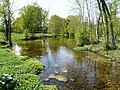
 Gué de l'Éperon
 -
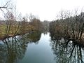 d'Ambon Pond
 -
 Le Boulou
 -
 L'Euche
 -
 Le Bullidour
 -
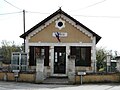 Town Hall
 -
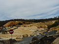 Calcium carbonate mine in Chauffour et Puy Pelan
 -
 Saint-Barthélemy church

.JPG)


.JPG)
.JPG)
See also
References
- ^ "Populations légales 2021". The National Institute of Statistics and Economic Studies. 28 December 2023.
Wikimedia Commons has media related to Creyssac.
| International | |
|---|---|
| National | |
This Dordogne geographical article is a stub. You can help Wikipedia by expanding it. |