Acol, Kent
| Acol | |
|---|---|
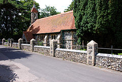
 St Mildred's Church, Acol | |
Location within Kent | |
| Population | 295 (2011 Census)[1] |
| OS grid reference | TR308673 |
| Civil parish |
|
| District | |
| Shire county | |
| Region | |
| Country | England |
| Sovereign state | United Kingdom |
| Post town | BIRCHINGTON |
| Postcode district | CT7 |
| Dialling code | 01843 |
| Police | Kent |
| Fire | Kent |
| Ambulance | South East Coast |
| UK Parliament | |
Acol (formerly Acholt) is a hamlet and civil parish about 1.5 miles (2.4 km) south of Birchington in Kent, England. It is one of the smallest communities in Kent, and over the years large parts of the parish have been transferred to other neighbouring communities.[2] Acol is situated just north of the Western end of the runway at Manston Airport.[3]
History
The aftermath of the Napoleonic War was a cruel time for small farmers and farm workers. Starvation wages, low prices and crippling taxes drove many to desperation and caused social upheavals on the land. At first sight, Cobbett was most impressed.[citation needed]
In reality, the condition for labourers throughout Kent at the time were deteriorating to the point where unrest brought about the start of the Swing Riots in 1833-4. At the same time, many labourers left Kent, often with the grateful assistance of their parish councils who did not want to keep supporting them, to take up new lives in the colonies in North America and particularly Australia and New Zealand.[citation needed]
St Mildred's Church
The Anglican parish church of St Mildred was designed by the architect C. N. Beazley, built in 1876 to serve as both a church and a school. The church, located on Plumstone Road towards the south of the hamlet, was built out of flint rubble in a Gothic Revival style. The construction utilises an inside stock brick walling faced externally with stone quoins, pilasters and buttresses, while the panels set between the stone work are filled using flint. The south side of the building is cut into the ground, providing extended interior space despite the exterior's diminutive size. The building's apse, which replaces the usual chancel arch found in similar churches of its size, contains stained glass windows which depict Christ's Crucifixion, Our Lady and St John the Evangelist, and were designed by Gibbs & Howard, who work out of Charlotte Street in Fitzroy Square, London.[4][5][6]
The Smugglers Leap
Close by Acol is the famous chalk pit where Exciseman Gill and Smuggler Bill met their deaths as told in the well-known poem, The Smuggler's Leap by Richard Harris Barham. Exciseman Gill sold his soul for a demon horse that had the ability to catch Smuggler Bill. In the swirling mist on that night in Thanet, just as Exciseman Gill caught up to the Smuggler, he drove his horse off the top of the chalk pit as did the Riding Officer. The bodies of the two men and only one horse were found later and are still said to haunt the area.[7]
References
- ^ "Civil Parish population 2011". Neighbourhood Statistics. Office for National Statistics. Retrieved 22 September 2016.
- ^ Notes on the history of the civil parish Archived 9 July 2009 at the Wayback Machine
- ^ "Acol Kent - Kent Places of Interest". Kentpoi. Retrieved 8 September 2017.
- ^ John E. Vigar's Kent Churches: St Mildred, Acol
- ^ Newman 1969, p. 103.
- ^ "History St Mildreds". All Saints Birchington with Acol and Minnis Bay. Retrieved 8 September 2017.
- ^ "The Ingoldsby Legends - THE SMUGGLER'S LEAP - A LEGEND OF THANET". The Ex-Classics. Retrieved 8 September 2017.


