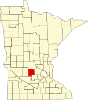
Acton, Minnesota
Acton, Minnesota | |
|---|---|
| Coordinates: 45°05′03″N 94°39′39″W / 45.08417°N 94.66083°W | |
| Country | United States |
| State | Minnesota |
| County | Meeker |
| Township | Acton Township |
| Elevation | 1,184 ft (361 m) |
| Time zone | UTC-6 (Central (CST)) |
| • Summer (DST) | UTC-5 (CDT) |
| ZIP code | 56243, 56209, and 55355 |
| Area code | 320 |
| GNIS feature ID | 654561[1] |
Acton is an unincorporated community in Acton Township, Meeker County, Minnesota, United States, near Grove City and Litchfield. The community is located along Meeker County Road 23 near State Highway 4 (MN 4). County Road 32 is also in the immediate area.
History
A post office called Acton was established in 1857, and remained in operation until 1904.[2] The community was named after Acton, Ontario.[3]
The Dakota War of 1862

The incident that sparked the Dakota War of 1862 took place near Acton on August 17, 1862. Four Mdowakantons from Rice Creek Village in the Lower Sioux Agency, returning home from an unsuccessful hunt, had a confrontation with Robinson Jones, a settler. The result of the dispute was that the Mdowakantons shot and killed five settlers, including Jones.[4]
On September 3, a 55-man company of the newly-formed 10th Minnesota Volunteer Infantry Regiment was routed by a band of Dakota warriors near Acton. The regiment managed to break free and were pursued eight miles to Hutchinson. Six of the soldiers were killed and 23 wounded; the number of Dakota dead and wounded is not known.[5]
References
Notes
- ^ "Acton, Minnesota". Geographic Names Information System. United States Geological Survey, United States Department of the Interior.
- ^ "Meeker County". Jim Forte Postal History. Retrieved 21 July 2015.
- ^ Upham, Warren (1920). Minnesota Geographic Names: Their Origin and Historic Significance. Minnesota Historical Society. p. 338.
- ^ Clodfelter 2006, p. 35–36
- ^ Clodfelter 2006, p. 53
Sources
- Clodfelter, Micheal (February 28, 2006). The Dakota War: The United States Army Versus the Sioux, 1862–1865. McFarland. ISBN 978-1-4766-0408-4.


