Alma (Crimea)
Appearance
| Alma | |
|---|---|
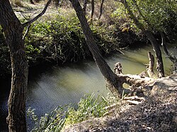
 Alma river near memorial of Battle of Alma | |
| Native name | Альма Error {{native name checker}}: parameter value is malformed (help) |
| Physical characteristics | |
| Source | |
| • location | Babuğan Yayla, Crimean Mountains |
| Mouth | |
• location | Kalamita bay of the Black Sea |
| Length | 83 km (52 mi) |
The Alma (Ukrainian: Альма; Russian: Альма, Crimean Tatar: Alma) is a small river in Crimea that flows into the Black Sea. Its mouth is located half-way between Yevpatoria and Sevastopol. Alma is the Crimean Tatar word for an "apple".
The Alma is formed by the confluence of the Sary-su, the Savlykh-su and the Babuganka (Babuğan Yayla) rivers, and flows mostly through the mountains.[1] The Alminskoye and Partizanskoye storage reservoirs are located along its course.[1]
Near the Alma river the allied British, French, and Ottoman armies defeated the Russians under Prince Aleksandr Sergeevich Menshikov 20 September 1854, see Battle of Alma.[2]
References
- ^ a b Grinevetsky, Sergei R.; et al., eds. (2014). "Alma". The Black Sea Encyclopedia. Berlin: Springer. p. 38. ISBN 978-3-642-55226-7.
- ^ Callary, Edward (29 September 2008). Place Names of Illinois. University of Illinois Press. p. 6. ISBN 978-0-252-09070-7.
44°50′45″N 33°35′38″E / 44.84583°N 33.59389°E
