Alter Südfriedhof
You can help expand this article with text translated from the corresponding article in German. (March 2009) Click [show] for important translation instructions.
|
| Alter Südfriedhof | |
|---|---|
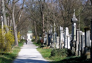
 View through the cemetery, from the north. | |
 | |
| Details | |
| Established | 1563 |
| Location | |
| Country | Germany |
| Type | Public (closed) |
| Size | ? |
| No. of graves | ? |


The Alter Südfriedhof (Old South Cemetery) also known as "Alter Südlicher Friedhof" is a cemetery in Munich, Germany. It was founded by Duke Albrecht V as a plague cemetery in 1563 about half a kilometer south of the Sendlinger Gate between Thalkirchner and Pestalozzistraße.
History
The cemetery was established in 1563, during the reign of Albert V, Duke of Bavaria, for victims of the plague and located outside the city gates. It was also the burial ground of the dead from the Sendling uprising of 1705, in which over 1100 were killed after they had surrendered to the troops of Joseph I, Holy Roman Emperor. From 1788 to 1867 it was the single collective burial ground for the dead of the city.
Notable interments
From 1788 to 1868 it was the only cemetery for the whole metropolitan area of Munich, which is why it contains the graves of several prominent Munich figures of that period.
- Max Emanuel Ainmiller - painter, 1807–1870
- Franz Xaver von Baader - philosopher, 1765–1841
- Jakob Bauer - first mayor, 1787–1854
- Theodor von Bischoff, anatomist and physician, 1807–1882
- Roman Anton Boos - sculptor, 1730–1810
- Friedrich Bürklein - architect, 1813–1872
- Adolf Christen, theatre director and producer, 1811–1883
- Anna Dandler, actress, 1862–1930
- Ernst Friedrich Diez - opera singer, 1805–1892
- Sophie Diez - opera singer, 1820–1887
- Johann Georg von Dillis - landscape painter, 1759–1841
- Ignaz von Döllinger - theologian, 1799–1890
- Johann Georg Edlinger - painter, 1741–1819
- Alexander Eibner, painter and painting tutor, 1862–1935
- Kaspar Ett - composer, 1788–1847
- Jakob Philipp Fallmerayer, traveller, journalist, politician and historian, 1790–1861
- Carl von Fischer - architect, 1782–1820
- Ludwig Foltz, architect, sculptor and illustrator, 1809–1867
- Joseph von Fraunhofer - optician and inventor, 1787–1826
- Franz Xaver Gabelsberger - shorthand inventor, 1789–1849
- Friedrich von Gärtner - architect, 1792–1847
- Sebastian Gaigl - founder of the city orphanage, 1799–1871
- Joseph Görres - publicist, 1776–1848
- Charlotte von Hagn - actress (appears in the Gallery of Beauties), 1809–1891
- Johann von Halbig - sculptor, 1814–1882
- August von Hauner - teacher and professor, 1811–1884
- Peter von Hess - painter, 1792–1871
- Wilhelm von Kaulbach - history painter, 1805–1878
- Leo von Klenze - architect, 1784–1864
- Franz von Kobell, mineralogist and Bavarian / Palatinate dialect poet, 1803–1882
- Alexander von Kotzebue, Russo-German battle-painter, 1815–1889
- Ludwig Lange, architect and painter, 1808–1868
- Georg Leib - Royal Councillor of Commerce and scaffolding specialist, 1846-1910
- Justus Freiherr von Liebig - chemist and natural scientist, 1803–1873
- Ferdinand von Miller - member of the Dt. Reichstag, 1813–1887
- Carl Friedrich Neumann - Sinologist, 1793–1870
- Eugen Napoleon Neureuther - painter, draughtsman and etcher, 1806–1882
- Johann Nepomuk von Nussbaum - surgeon, 1829–1890
- Georg Simon Ohm - physicist, 1789–1854
- Max von Pettenkofer - important physician, 1818–1901
- Ludwig von der Pfordten - Bavaria's Ministerpräsident, 1811–1899
- Christian Pram-Henningsen, Danish painter, 1846–1892
- Siegmund von Pranckh, general and Defence Minister, 1821–1888
- Georg Friedrich von Reichenbach - inventor and engineer, 1772–1826
- Josef Gabriel Rheinberger, composer and music teacher from Liechtenstein, 1839–1901
- Karl Rottmann - landscape painter, 1798–1830
- Eduard Schleich the Elder - painter, 1813–1874
- Friedrich Ludwig von Sckell - landscape gardener, 1750–1823
- Ludwig Schwanthaler - sculptor, 1802–1848
- Moritz von Schwind - painter, 1804–1871
- Helene Sedlmayr - symbol of Schönen Münchnerin in the Gallery of Beauties, 1813–1898
- Franz von Seitz - painter, lithographer and costume painter, 1817-1883
- Otto Seitz - painter and teacher, 1846–1912
- Alois Senefelder - inventor of lithography, 1771–1834
- Johann Nepomuk Sepp - historian and politician, 1816–1909
- Carl Spitzweg - painter and apothecary, 1808–1885
- Carl August von Steinheil - physicist, 1801-1870
- Friedrich Wilhelm von Thiersch, "Praeceptor Bavariae", 1784–1860
- Gustav Vorherr - architect, 1778–1847
- Klara Ziegler, actress and theatre founder, 1844–1909
- Anton Zwengauer, landscape painter, 1810-1884
- Gottlieb Bodmer, painter and lithographer, 1804-1837
Current use
The cemetery today serves as an Art and Cultural history monument, and is open to the public as an official Munich park. Most of the monuments, which suffered from exposure to weather and pollution, have been renovated and cleaned, in a three-year project (2004–2007). The St. Stephan's church has also been renovated.
