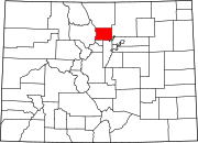
Altona, Colorado
Appearance
Altona, Colorado | |
|---|---|
| Country | |
| State | |
| County | Boulder[1] |
| Area | |
| • Total | 1.7 sq mi (4.5 km2) |
| • Land | 1.7 sq mi (4.4 km2) |
| • Water | 0.04 sq mi (0.1 km2) |
| Elevation | 5,600 ft (1,707 m) |
| Population (2010) | |
| • Total | 501 |
| • Density | 297/sq mi (114.8/km2) |
| Time zone | UTC-7 (MST) |
| • Summer (DST) | UTC-6 (MDT) |
| GNIS feature ID | 0178293[2] |
Altona is a census-designated place (CDP) in Boulder County, Colorado, United States.[2] As of the 2010 census it had a population of 501.[3]
Geography
Altona is located in central Boulder County at 40°7′21″N 105°17′46″W / 40.12250°N 105.29611°W (40.1225330, -105.2960570),[2] where Left Hand Creek exits the Front Range of the Colorado Rockies. U.S. Highway 36 passes through the community, leading north to Lyons and south to Boulder. Altona is 10 miles (16 km) west of Longmont by Nelson Road.
According to the U.S. Census Bureau, the Altona CDP has a total area of 1.7 square miles (4.5 km2), of which 1.7 square miles (4.4 km2) is land and 0.039 square miles (0.1 km2), or 3.31%, is water.[3]
See also
References
- ^ a b "US Board on Geographic Names". United States Geological Survey. 2007-10-25. Retrieved 2008-01-31.
- ^ a b c U.S. Geological Survey Geographic Names Information System: Altona, Colorado
- ^ a b "Geographic Identifiers: 2010 Demographic Profile Data (G001): Altona CDP, Colorado". U.S. Census Bureau, American Factfinder. Retrieved September 27, 2013.
External links
Wikimedia Commons has media related to Altona, Colorado.
- Altona entry at Ghosttowns.com
- Altona Grange #127

