Altona, Ontario
Altona | |
|---|---|
Unincorporated community | |
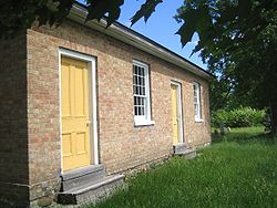
 Altona Mennonite Meeting House, 1852 | |
 | |
| Country | Canada |
| Province | Ontario |
| Regional municipality | Durham Region |
| Town | Pickering, Ontario |
| Elevation | 267 m (876 ft) |
| Time zone | UTC−5 (EST) |
| • Summer (DST) | UTC−4 (EDT) |
Altona is a ghost town located in Pickering, Ontario, at Sideline 30 and the Pickering-Uxbridge Town Line. It is just east of Whitchurch-Stouffville, and was named after Altona, now a borough of Hamburg, Germany.[1]

It was founded by ethnic Swiss-German Mennonites who had migrated from Pennsylvania in the United States. The first flour and saw mills in Altona were built by Abraham Reesor, son of Peter Reesor and a nephew to Abraham Stouffer, in 1850, on Lot 30, Concession 9, a short distance south of the Uxbridge-Pickering Townline.[2] In the same year, Joseph Monkhouse built a general store and William Cooper an inn.[3]

In 1852, the Altona Mennonite Meeting House (5475 Sideline 30, Pickering) was erected,[4] constructed by area Mennonite settlers. The bricks were made at the Cherrywood brick yard. Local families included the Barkeys, Reesors, Widemans, Nighswanders, Hoovers and Stouffers.[5] The first grave is dated 1835. The founder of Stouffville, Abraham Stouffer and his wife Elizabeth Reesor Stouffer, are buried here.[6]
The first schoolhouse was built in 1834; in 1856 there were 256 inhabitants, "unable to read and write, about 30%."[7] By 1869 the hamlet had 200 residents and a regular stage coach to Stouffville and Toronto.[8] In 1910 there was still a daily stage to Stouffville, but Altona's population had fallen to only 100 people.[9]
Today, the churches, school, store (former hotel) and homes remain {currently only a few houses spot the area, the hotel is gone, at least one church is gone, as are the majority of the homes}, but all have been expropriated and most boarded up by the federal government for a proposed plan to build a second international airport (Pickering airport) in the Greater Toronto Area.[10] One of the few remaining houses is the "Old Barkey Home," built in 1856 by the Mennonite farmer and preacher Daniel Barkey.[11] Under the current plan, the approach for one of the three landing strips for the Pickering Airport would be directly over the former hamlet of Altona, with planes descending at an elevation of approximately 300 metres. The plan anticipates 11.9 million passengers per year (or 32,600 per day) by 2032.[12] A "Needs Assessment Study" was completed by the Greater Toronto Airports Authority for the federal government in May 2010. After a "due diligence review," Transport Canada released the report in July 2011.[13]
References
- ^ Cf. Joseph Nighswander, A Brief History of Altona Archived 2011-07-06 at the Wayback Machine, Canadian-German Folklore: More Pioneer Hamlets of York 9 (1985), 21f.
- ^ Cf. J. Nighswander, A Brief History of Altona Archived 2011-07-06 at the Wayback Machine, Canadian-German Folklore: More Pioneer Hamlets of York 9 (1985), 21-28; also John W. Sabean's history of Altona: Historical Report: Reesor Mill House, Altona Archived 2011-07-06 at the Wayback Machine (Pickering, 2005).
- ^ "Focus on Altona Archived 2011-09-28 at the Wayback Machine," Pathmaster (Pickering Township Historical Society) 4, no. 3 & 4 (Spring/Summer 2002), 27.
- ^ Global Anabaptist Mennonite Online Encyclopedia, Altona Mennonite Meeting House.
- ^ Cf. William Robertson Wood, Past years in Pickering: Sketches of the history of the community (Toronto, ON: W. Briggs, n.d.), 179, 239, 250, 272, 291. See also the 1877 map of Pickering Township with names of landowners, lots and concessions: Historical Atlas of Ontario County.
- ^ For names and photos of some of the headstones at the cemetery, cf. CanadaWebGen.org, Altona Mennonite Cemetery Archived July 25, 2011, at the Wayback Machine.
- ^ Cf. W.R. Wood, Past years in Pickering: sketches of the history of the community, 179.
- ^ H. McEvoy, ed., The Province of Ontario Gazetteer and Directory (Toronto: Robertson and Cook, 1869), 25.
- ^ Province of Ontario Gazetteer and Directory, 1910-11, (Ingersoll, ON: Union Publishing, 1911), 17.
- ^ Cf. the photo essay by Paolo De Marchi, Altona: Abandoned Buildings of Durham
- ^ See picture of the historic "Barkey-O'Connor House Archived 2011-09-28 at the Wayback Machine", PADA: Pickering-Ajax Digital Archive, accessed June 9, 2011.
- ^ Cf. Transport Canada, Plan Showing Pickering Airport Site; also Greater Toronto Airports Authority, Pickering Airport Draft Plan Report, 2004.
- ^ Transport Canada, News Release: "Transport Canada releases findings of the 2010 Pickering Lands Needs Assessment Study Archived 2011-11-02 at the Wayback Machine," July 11, 2011.
