
Ammersee
| Ammersee Lake Ammer | |
|---|---|
 winter 2006 | |
 map | |
| Location | Upper Bavaria |
| Coordinates | 48°00′N 11°07′E / 48.000°N 11.117°E |
| Primary inflows | River Ammer |
| Primary outflows | Amper |
| Catchment area | 993.0 km2 (383.4 sq mi) |
| Basin countries | Germany |
| Max. length | 16.2 km (10.1 mi) |
| Max. width | 5 km (3.1 mi) |
| Surface area | 46.6 km2 (18.0 sq mi) |
| Average depth | 37.8 m (124 ft) |
| Max. depth | 81 m (266 ft) |
| Residence time | 2.7 years |
| Surface elevation | 533 m (1,749 ft) |
| Islands | Schwedeninsel |
| Settlements | Herrsching, Dießen am Ammersee |
| Designated | 26 February 1976 |
| Reference no. | 93[1] |
Ammersee (English: Lake Ammer) is a Zungenbecken lake in Upper Bavaria, Germany, southwest of Munich between the towns of Herrsching and Dießen am Ammersee. With a surface area of approximately 47 square kilometres (18 sq mi), it is the sixth largest lake in Germany. The lake is at an elevation of 533 metres (1,749 ft), and has a maximum depth of 81 metres (266 ft). Like other Bavarian lakes, Ammersee developed as a result of the ice age glaciers melting. Ammersee is fed by the River Ammer, which flows as the Amper out of the lake. Like neighbouring Lake Starnberg, which is similar in size and shape, it is a popular location for watersports.
Ammersee and the Amper are part of the ancient Celtic amber trading route leading to the Brenner Pass. The word Ammer is a 13th-century form of Amper, the Celtic *ambra, deriving from the Indo-European *ombh-, *mbh- "wet, Water".[2]
Passenger services have operated on the lake since 1879. Today they are operated by the Bayerische Seenschifffahrt company, using a mixture of historic paddle steamers and motor ships.[3][4]
Ecology
The lake's water generally has been of very good quality since a circular sewerage system was introduced in the 1960s collecting all wastewater from around the lake and transporting it to a treatment plant below the lake's outlet at Eching.
The Ammersee abounds with fish[5] and is the home of the vulnerable species of deepwater char Salvelinus evasus.[6]
Deepwater char are highly sensitive to changes in the quality of the water and some species such as Salvelinus neocomensis and Salvelinus profundus were driven recently to extinction in other European lakes.[7]
Gallery
-
 Eastern shore
 -
 Autumn
 -
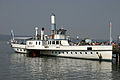 Paddle Steamer Diessen on the lake


References
- ^ "Ammersee". Ramsar Sites Information Service. Retrieved 25 April 2018.
- ^ Dieter Berger: Duden - Geographische Namen in Deutschland. 2nd ed., Dudenverlag, 1999, ISBN 978-3-411-06252-2.
- ^ "Bayerische Seenschifffahrt". Bayerische Seenschifffahrt. Archived from the original on 2011-07-16. Retrieved 11 July 2011.
{{cite web}}: Unknown parameter|deadurl=ignored (|url-status=suggested) (help) - ^ "Geschichtliche Hintergründe" [Historical Background] (in German). Bayerische Seenschifffahrt. Archived from the original on 10 December 2011. Retrieved 11 July 2011.
{{cite web}}: Unknown parameter|deadurl=ignored (|url-status=suggested) (help) - ^ The Penny Cyclopaedia of the Society for the Diffusion of Useful Knowledge. Charles Knight. 1835.
- ^ Revue Suisse de Zoologie - Salvelinus evasus[permanent dead link]; accessed 24 January 2018.
- ^ "Red List - Volume 1: Vertebrates (2009) - General assessment for the vertebrate groups". Archived from the original on 2013-06-23. Retrieved 2012-12-29.
{{cite web}}: Unknown parameter|dead-url=ignored (|url-status=suggested) (help)
External links
 Media related to Ammersee at Wikimedia Commons
- Nixdorf, B.; et al. (2004), "Ammersee", Dokumentation von Zustand und Entwicklung der wichtigsten Seen Deutschlands (in German), Berlin: Umweltbundesamt, p. 8
- Pictures of the Ammersee
| International | |
|---|---|
| National | |
This Bavaria location article is a stub. You can help Wikipedia by expanding it. |