
Angeghakot
Angeghakot
Անգեղակոթ | |
|---|---|
 | |
 Angeghakot  Angeghakot | |
| Coordinates: 39°34′05″N 45°56′38″E / 39.56806°N 45.94389°E | |
| Country | Armenia |
| Province | Syunik |
| Municipality | Sisian |
| Area | |
| • Total | 45.79 km2 (17.68 sq mi) |
| Population | |
| • Total | 1,582 |
| • Density | 35/km2 (89/sq mi) |
| Time zone | UTC+4 (AMT) |
| Angeghakot at GEOnet Names Server | |
Angeghakot (Armenian: Անգեղակոթ) is a village in the Sisian Municipality of the Syunik Province in Armenia. A large reservoir, the Angeghakot Reservoir, spanning more than the entire length of the village lies to the south.
Demographics
[edit]In 1908, Angeghakot, then known as Angelaut (Russian: Ангелаут), had a predominantly Armenian population of 1,520 within the Zangezur uezd of the Elizavetpol Governorate of the Russian Empire.[3] The Statistical Committee of Armenia reported its population as 2,057 in 2010,[4] up from 1,860 at the 2001 census.[5]
Notable people
[edit]- Oksen Mirzoyan, Olympic, world and European champion in weightlifting
Godedzor
[edit]About 1,5 kilometres west of Angeghakot is located an important prehistorical archaeological site of Godedzor.[6] The settlement of Nerkin Godedzor is in the Vorotan river gorge, at the altitude of 1800 meters. Some petroglyphs are also found close by.
In 2003, an archaeological survey revealed prehistoric cultural deposits distinguished by a distinctive stone industry and ceramics. The site is on the left bank of a river. Plenty of obsidian artifacts were found at Godedzor. The Syunik obsidian (especially from Sevkar) has been identified in many artefacts from the Near East. Especially they have been found in the Lake Urmia basin in Iran.[7] Godedzor was a big hub of obsidian trade in the South Caucasus.
Gallery
[edit]-
 Angeghakot Reservoir
 -
 Hazaraprkich Church
 -
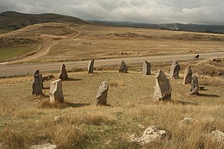 Megalithic rings in Angeghakot
 -
 Khachkar
 -
 Saint Vardan chapel
 -
 Khachkar


.jpg)


References
[edit]- ^ "Syunik regional e-Governance System" (in Armenian). Syunik Province provincial government. Click on link entitled "Համայնքներ" (community) and search for the place by Armenian name.
- ^ Statistical Committee of Armenia. "The results of the 2011 Population Census of Armenia" (PDF).
- ^ Кавказский календарь на 1910 год [Caucasian calendar for 1910] (in Russian) (65th ed.). Tiflis: Tipografiya kantselyarii Ye.I.V. na Kavkaze, kazenny dom. 1910. Archived from the original on 15 March 2022.
- ^ "Marzes of Armenia and Yerevan City in Figures, 2010" (PDF). Statistical Committee of Armenia.
- ^ Report of the results of the 2001 Armenian Census, Statistical Committee of Armenia
- ^ Patel Avetisyan, Christine Chataigter, Gillio Palumbi 2006, The results of the excavations in Nerkin Godedzor (2005–2006) Preliminary report. - academia.edu
- ^ Main routes of communication between obsidian sources of Syunik, Kul Tepe and Lake Urmia Basin. in Khademi Nadooshan, Farhang; Abedi, Akbar; Glascock, Michael D.; Eskandari, Nasir; Khazaee, Mostafa (2013). "Provenance of prehistoric obsidian artefacts from Kul Tepe, northwestern Iran using X-ray fluorescence (XRF) analysis". Journal of Archaeological Science. 40 (4): 1956–1965. doi:10.1016/j.jas.2012.12.032.

This article about a location in Syunik Province, Armenia is a stub. You can help Wikipedia by expanding it. |