Anzac Village, New Mexico
Anzac Village, New Mexico | |
|---|---|
| Coordinates: 35°3′36″N 107°44′31″W / 35.06000°N 107.74194°W | |
| Country | United States |
| State | New Mexico |
| County | Cibola |
| Area | |
| • Total | 0.56 sq mi (1.44 km2) |
| • Land | 0.56 sq mi (1.44 km2) |
| • Water | 0 sq mi (0 km2) |
| Elevation | 6,320 ft (1,930 m) |
| Population (2010) | |
| • Total | 54 |
| • Density | 97/sq mi (37.4/km2) |
| Time zone | UTC-7 (Mountain (MST)) |
| • Summer (DST) | UTC-6 (MDT) |
| Area code | 505 |
| FIPS code | 35-03970 |
| GNIS feature ID | 2585647 |
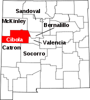
Anzac Village is a census-designated place (CDP) in Cibola County, New Mexico, United States. The population was 54 at the 2010 census.[1]
Geography
Anzac Village is located in northern Cibola County at 35°3′36″N 107°44′31″W / 35.06000°N 107.74194°W, in the northwest corner of the Acoma Indian Reservation. It is bordered on the north by Anzac Road in the valley of the Rio San Jose; the road connects with Historic U.S. Route 66 to the east and west.
According to the United States Census Bureau, the CDP has a total area of 0.56 square miles (1.44 km2), all land.[1]
References
- ^ a b "Geographic Identifiers: 2010 Demographic Profile Data (G001): Anzac Village CDP, New Mexico". U.S. Census Bureau, American Factfinder. Retrieved October 17, 2014.


