Arlington, New Jersey
Appearance
Arlington, New Jersey | |
|---|---|
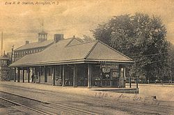
 The old Arlington Train Station, circa 1910 | |
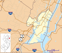
| Coordinates: 40°46′39″N 74°08′18″W / 40.77750°N 74.13833°W | |
| Country | United States |
| State | New Jersey |
| County | Hudson |
| Town | Kearny |
| Elevation | 118 ft (36 m) |
| Area code | 201 |
| GNIS feature ID | 874373[1] |
Arlington is a neighborhood in Kearny in Hudson County, New Jersey, United States.[2] Kearny Riverbank Park runs along the neighborhood's Passaic River shore. Arlington Memorial Park cemetery is located on Schuyler Avenue.[3]
The community was the location of a railroad station on New Jersey Transit, just east of the WR Draw over the river, which was discontinued with the opening of the Montclair Connection and Secaucus Junction. The Bergen County town of North Arlington takes its name in relation to this community, which it borders.
References
- ^ a b "Arlington". Geographic Names Information System. United States Geological Survey, United States Department of the Interior.
- ^ Locality Search Archived 2016-07-09 at the Wayback Machine, State of New Jersey. Accessed February 7, 2015.
- ^ "Archived copy" (PDF). Archived from the original (PDF) on 2015-02-07. Retrieved 2015-02-07.
{{cite web}}: Unknown parameter|deadurl=ignored (|url-status=suggested) (help)CS1 maint: archived copy as title (link)


