
Hurstville, New South Wales
| Hurstville Sydney, New South Wales | |||||||||||||||
|---|---|---|---|---|---|---|---|---|---|---|---|---|---|---|---|
 Memorial Square, Forest Road, Hurstville | |||||||||||||||
| Population | 25,663 [citation needed] | ||||||||||||||
| • Density | Lua error: Unable to convert population "25663 <sup class="noprint Inline-Template Template-Fact" style="white-space:nowrap;">[<i><span title="This claim needs references to reliable sources.">citation needed</span></i>]</sup>" to a number. | ||||||||||||||
| Established | 1887 | ||||||||||||||
| Postcode(s) | 2220 | ||||||||||||||
| Area | 4.2 km2 (1.6 sq mi) | ||||||||||||||
| Location | 16 km (10 mi) from CBD | ||||||||||||||
| LGA(s) | City of Hurstville | ||||||||||||||
| State electorate(s) | Electoral district of Hurstville | ||||||||||||||
| Federal division(s) | Division of Watson | ||||||||||||||
| |||||||||||||||


Hurstville is a suburb in southern Sydney, in the state of New South Wales, Australia. Hurstville is located 16 kilometres south of the Sydney central business district and is part of the St George area. Hurstville is the administrative centre of the local government area of the City of Hurstville. The postcode is 2220.
Hurstville has become a central business district for the southern suburbs of Sydney. It is a large, enterprising, multi-cultural city with its development of commercial buildings and high-rise residential buildings dominating the skyline. Hurstville's residential developments are a mixture of low density housing, medium density flats and high density apartment buildings. As a commercial centre, it features branches of many banks, financial institutions, insurance companies and retail shops. Forest Road features many restaurants, particularly Chinese cuisine, as well as a number of cafes and pubs.
History
Hurstville comes from the words 'hurst' meaning wooded emminence and 'ville' meaning town. [1]
Aboriginal Culture
The first inhabitants in the Hurstville area were Australian Aborigines. It is unknown when Aborigines first settled the Hurstville region. Some estimates have put it as far back as 100,000 years ago while others contend that it is as low as 10,000 years ago. [citation needed] At the time of the arrival of the First Fleet the aborigines living in Hurstville were part of the Eora tribe which stretched along the Georges River from Botany Bay to present day Liverpool.
European Settlement
The land of the Hurstville region was granted by the government of the new colony of New South Wales to two men; Captain John Townson and his brother Robert Townson in 1808. Captain John Townson was granted 1950 acres (7.9 km²) of land which is now occupied by the suburb of Hurstville and part of Bexley. Robert Townson was granted the land which is now occupied by Penshurst, Mortdale and parts of Peakhurst. In the same year, in the area now known as Riverwood land grants were made to Jane Trotter, Mary Shepley, Charles Doudall, and James Ryan. Later in 1816 another land grant in the same area was given to Mary Redman.
In 1909, Captain John Townson was granted an additional 250 acres (1 km²) in the area now occupied by Kingsgrove and Beverly Hills. The Townson brothers were not happy with the land that they were given because it was not suitable for the farming of sheep for wool and it is likely that the brothers never occupied their land. In 1812, a wealthy merchant named Simeon Lord bought the land of Captain John Townson and named it Lord's Forest. When Simeon Lord died the land became the property of John Rose Holden and James Holt of the Bank of NSW.
Development
A dam with a roadway on top was constructed on the Cooks River at Tempe in 1839. In 1843 the road which was to become known as Forest Road was extended from the dam to a hand winched punt in Lugarno. On the other side of the river the road continued all the way to Wollongong, however it was only suitable for travellers on horseback. The new road opened up the Hurstville region and created a settlement at Bottle Forest, now known as Heathcote.
In 1850 the Lord Forest estate was purchased by Michael Gannon (1800-61) who subdivided it into small farms along what is now Croydon Road and three larger farms purchased by Dent, Peake and Ibbotson. The area became known as Gannons Forest. The land originally granted to Robert Townson was purchased by John Connell in 1830, and following his death in 1849 the estate was inherited by his grandsons Elias Pearson Laycock and John Connell Laycock.
The Gannons Forest post office opened in 1881. The local school was named 'Hurstville' by School Inspector MacIntyre when it was established in 1876. When the railway station opened in the 15th October 1884, it took the name Hurstville, from the school. Hurstville municipality was incorporated in 1887. Hurstville was declared a city in 1988. The Centennery Bakery on Forest Road is a historic building that has been preserved and once housed a museum. The St George Regional Museum is now located in another historic building in MacMahon Street.
The Hurstville train crash on the 3rd August 1920 resulted in five people killed and fifty injured. It involved the collision of two steam trains, one arriving from Central plunged into the back of the other bound that was stationary at Hurstville railway station, bound for Sutherland. [2]


Commercial Area
Hurstville's commercial area is centred around the main street, Forest Road, on the northern side of Hurstville Railway station. The commercial developments also extend to surrounding streets concentrated from Queens Road to The Avenue and on the southern side of Hurstville Railway station, around Ormonde Parade. The commercial developments extend further along Forest Road, west towards Penshurst and east towards Bexley.
Westfield Hurstville is the largest shopping centre in the St George area. It is built over three blocks and stretches from Forest Road over Crofts Street, Park Avenue to The Avenue. Hurstville Super Centre is a small shopping centre built over Hurstville Railway station, which links Forest Road with Ormonde Parade. The Super Centre is currently being reconstructed to Hurstville Central.
The administrative offices of the City of Hurstville are located in the Hurstville Civic Centre in MacMahon Street. This street also features a number of historic buildings such as the Friendly Pharmacy, old Fire Station, Ritz Hotel and the St George Regional Museum.
Transport
Hurstville railway station is a station on the Illawarra line of the City Rail network. All suburban and most interurban trains stop at Hurstville. Hurstville is 20 minutes from Sydney Central railway station on the express service. Hurstville is a major bus interchange with bus services departing from Forest Road and Ormonde Parade.
Churches
- St Georges Anglican Church, St Michaels Catholic Church, Hurstville Presbyterian Church, Hurstville Church of Christ, Hurstville Uniting Church, Hurstville Seventh-day Adventist Church, Hurstville Assemblies of God, Salvation Army.
-
 Hurstville Uniting Church
 -
 Hurstville Presbyterian Church
 -
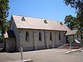
 Church of Christ
 -
 Hurstville Baptist Church


-
 St Michaels Catholic Church
 -
 St Michaels day care centre
 -
 Convent of St Mary's Star of the Sea
 -
 St Georges Anglican Church


Schools
- Bethany College, Hurstville Public School, Hurstville Boys High School, Danebank Anglican Girls School, Beverly Hills Public School, St George Christian School.
-
 Hurstville Public School

Landmarks

- Hurstville Civic Centre, Hurstville Entertainment Centre, Hurstville City Library, St George Regional Museum.
-
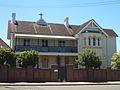
 Friendly Pharmacy, MacMahon Street
 -
 Centenary Bakery, Forest Road
 -
 Old Fire Station, MacMahon Street
 -
 St George Regional Museum


-
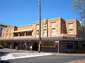 Hurstville Ritz Hotel, Forest Road
 -
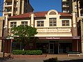
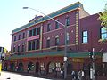 Hurstville Meridian Hotel, Forest Road
 -
 Hurstville Entertainment Centre
 -
 Hurstville Civic Theatre


-
 Hurstville City Library
 -
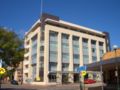
 former State Bank building, Hurstville
 -
 MacMahon St and Barratt St, Hurstville
 -
 Hurstville City Council Chambers


Parks
- Kempt Field, Woodville Park, Hurstville Park, Thorpe Park, Doyle Gardens.
-
 Woodville Park
 -
 Hurstville Park


Population
Demographics
The first European settlers in the area were mostly of British and Irish ancestry. From the late 1960s, Hurstville like many surrounding areas became home to migrants from all around the world. The first wave of migrants included Greeks and Italians who began moving south from Sydney's inner-city suburbs. They were followed by more European migrants including many from the former Yugoslavia, such as Macedonia. From the 1990s, the Chinese community within Hurstville has grown considerably. Much of this was related to significant migration from Hong Kong during the 1990s. Many local businesses are operated by people of Chinese background, the interests of which are advanced by the St. George Asian Business Association. Hurstville is a hub for Asian groceries, food and services.
According to the 2006 census, the population of Hurstville was 25,633 inhabitants, of which 55.8% were born overseas. In 2006, Hurstville had a Chinese plurality: 42.1% of the population were of Chinese ancestry, 12.4% of Australian ancestry, 10.5% of English ancestry and 35% of other or undeclared ancestry. The most common language spoken at home was English (29.5%), followed by Cantonese (19.5%), Mandarin (19.4%) and Greek (4.5%)although an influx of immigrants from mainland China is rapidly increasing the amount of people speaking Mandarin.[3]
Notable residents
- Sir Jack Brabham - Three-time Formula One World Champion, was born in Hurstville in 1926.
- Neville Hayes - Dual Olympic silver medallist in swimming, was born in the suburb in 1943.
- Craig Nicholls - The lead singer, songwriter and guitarist of the rock group The Vines. Born August 31, 1977.
References
- ^ City of Hurstville - History of Hurstville
- ^ The Book of Sydney Suburbs, Compiled by Frances Pollen, Angus & Robertson Publishers, 1990, Published in Australia ISBN 0-207-14495-8
- ^ Hurstville - 2006 census results