Augustów
Augustów | |
|---|---|
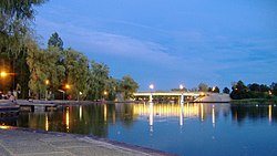
 Boulevard in Augustów | |
| Country | |
| Voivodeship | Podlaskie |
| County | Augustów County |
| Gmina | Augustów (urban gmina) |
| Established | 1546 |
| Town rights | 1550 |
| Government | |
| • Mayor | Kazimierz Kozuchowski |
| Area | |
| • Total | 80.93 km2 (31.25 sq mi) |
| Population (2006) | |
| • Total | 30,054 |
| • Density | 370/km2 (960/sq mi) |
| Time zone | UTC+1 (CET) |
| • Summer (DST) | UTC+2 (CEST) |
| Postal code | 16-300 to 16-303 |
| Area code | +48 87 |
| Car plates | BAU |
| Website | http://www.um.augustow.pl |
Augustów Template:Audio-IPA-pl (Lithuanian: Augustavas) is a town in north-eastern Poland with 29,600 inhabitants (1995). It lies on the Netta River and the Augustów Canal.
It is situated in the Podlaskie Voivodeship (since 1999), having previously been in Suwałki Voivodeship (1975–1998). It is the seat of Augustów County and of Gmina Augustów.
The town was first mentioned in 1496 and was granted city rights by king Sigismund II in 1557. Until 1569 Augustów belonged to the Grand Duchy of Lithuania when the Real union called Union of Lublin was signed between Poland, Grand Duchy of Lithuania and Royal Prussia. As a result, the town became a part of the Kingdom of Poland, while its cemetery was left in the Grand Duchy of Lithuania. Tatar invaders destroyed Augustów in 1656, and the second half of the 17th century saw the town afflicted by plague.
In 1795 Prussia annexed Augustów. In 1807 it became part of the Duchy of Warsaw, followed by incorporation into the Kingdom of Poland in 1815. It was made a county seat in 1842. The first railway connection reached Augustów in 1899.
During World War I, the Russian army successfully counterattacked the German army across Augustów in 1914. In the aftermath of World War I, it was a site of the Battle of Augustów in 1920. From 1939 to 1941, Soviet troops occupied the town. Many inhabitants were sent to exile in Kazachstan, from where some were able to return after 6 years. The Nazi German forces occupied Augustów until 1944. World War II brought destruction of about 70% of the town and death or departure of most of its residents, amongst them a community of several thousand Jews who were imprisoned in the ghetto situated between the canal and the river. The Germans executed practically all of them before they left. In 1945 the Soviets conducted the nearby Augustów chase 1945 - a special operation against former Armia Krajowa anticommunist fighters.
In 1970 Augustów officially became a health-cure resort, and in 1973 adjoining local villages were made a part of it.
Augustów ring road controversy
The construction of the Augustów bypass called Via Baltica, through the wetlands of the Rospuda Valley, attracted great controversy in 2007. The work was halted after the European Commission applied for an immediate injunction. See Rospuda River, European route E67.[1]
Augustowo
The town of Augustów, according to Encyclopædia Britannica Eleventh Edition (1911), was also known in English as Augustowo, located on a canal (65 mi.) connecting the Vistula with the Neman River. It was founded in 1557 by Sigismund II Augustus, hence its name, and laid out in a very regular manner, with a spacious market-place. It carried a large trade in cattle and horses, and manufactured linen and huckaback. Population in 1897 was 12,746.
Tourism
The town, although small, it full of places to see. An army Yacht club built in the 1930s has been restored and converted into a hotel can be seen on the edge of one of many lakes in the region.[1] Pope John Paul II has a memorial chair from the first and last time he visited the town right outside the club. Boat tours are also popular, and the old town square still has its original cobblestone streets.
Twin towns
Porto Ceresio-Italy, Tuusula-Finland, Szklarska Poręba-Poland
See also
References
This article incorporates text from a publication now in the public domain: Chisholm, Hugh, ed. (1911). Encyclopædia Britannica (11th ed.). Cambridge University Press. {{cite encyclopedia}}: Missing or empty |title= (help)


