
Department of Ayacucho
Ayacucho is a region of Peru, located in the south-central Andes of the country. Its capital is the city of Ayacucho. The region was one of the hardest hit by terrorism during the 1980s during the guerrilla war waged by Shining Path known as the internal conflict in Peru.
A referendum was held on October 30, 2005 in order to decide whether the region would merge with the regions of Ica and Huancavelica to form the new Ica-Ayacucho-Huancavelica Region, as part of the decentralization process in Peru. The bill failed and Ayacucho remained an independent region.
Political division

The region is divided into 11 provinces (Spanish: provincias, singular: provincia), which are composed of 111 districts (distritos, singular: distrito).
Provinces
The provinces, with their capitals in parenthesis, are:
- Cangallo (Cangallo)
- Huamanga (Ayacucho)
- Huanca Sancos (Huanca Sancos)
- Huanta (Huanta)
- La Mar (San Miguel)
- Lucanas (Puquio)
- Parinacochas (Coracora)
- Paucar del Sara Sara (Pausa)
- Sucre (Querobamba)
- Víctor Fajardo (Huancapi)
- Vilcas Huamán (Vilcas Huamán)
The People
Languages
According to the 2007 Peru Census, the language learnt first by most of the residents was Quechua (63.05%) followed by Spanish (36.57%). The following table shows the results concerning the language learnt first in the Ayacucho Region by province:[1]
| Province | Quechua | Aymara | Asháninka | Another native language | Spanish | Foreign language | Deaf or mute | Total |
|---|---|---|---|---|---|---|---|---|
| Cangallo | 29,356 | 24 | 4 | 11 | 3,132 | 3 | 37 | 32,567 |
| Huamanga | 104,644 | 223 | 42 | 118 | 102,452 | 72 | 218 | 207,769 |
| Huanca Sancos | 8,017 | 29 | 1 | - | 1,858 | - | 18 | 9,923 |
| Huanta | 58,333 | 89 | 92 | 40 | 28,184 | 5 | 105 | 86,848 |
| La Mar | 64,815 | 64 | 127 | 58 | 12,950 | 1 | 111 | 78,126 |
| Lucanas | 26,153 | 152 | 7 | 49 | 35,282 | 10 | 78 | 61,731 |
| Parinacochas | 15,491 | 68 | - | 30 | 12,576 | 2 | 29 | 28,196 |
| Paucar del Sara Sara | 5,223 | 19 | 1 | 15 | 5,140 | - | 16 | 10,414 |
| Sucre | 9,059 | 25 | - | - | 2,749 | - | 13 | 11,846 |
| Víctor Fajardo | 20,647 | 37 | 2 | 9 | 3,213 | - | 38 | 23,946 |
| Vilcas Huaman | 19,884 | 14 | 2 | 11 | 2,232 | 1 | 44 | 22,188 |
| Total | 361,622 | 744 | 278 | 341 | 209,768 | 94 | 707 | 573,554 |
| % | 63.05 | 0.13 | 0.05 | 0.06 | 36.57 | 0.02 | 0.12 | 100.00 |
Gallery
-
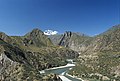 The Andes go across the Ayacucho Region
 -
 Statue of Antonio José de Sucre and obelisk near Kinwa, commemorating the Battle of Ayacucho.
 -
 Hot springs in the region of Ayacucho.
 -
 Obelisk near Kinwa, commemorating the Battle of Ayacucho.
 -
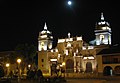 Church of Ayacucho


Sources
- ^ inei.gob.pe INEI, Peru, Censos Nacionales 2007
External links
Peru's Lima Province is not part of any region. |
13°09′47″S 74°13′28″W / 13.16306°S 74.22444°W
This Ayacucho Region geography article is a stub. You can help Wikipedia by expanding it. |