
Barren Island (Andaman Islands)
 Barren Island Location of Barren Island | |
| Geography | |
|---|---|
| Location | Bay of Bengal |
| Coordinates | 12°17′N 93°52′E / 12.28°N 93.86°E |
| Archipelago | Andaman Islands |
| Adjacent to | Indian Ocean |
| Administration | |
| Demographics | |
| Demonym | Hindi |
| Population | 0 |
| Additional information | |
| Time zone | |
| PIN | 744202[1] |
| Telephone code | 031927 [2] |
| Official website | www |
| Barren Volcano | |
|---|---|
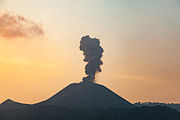
 Barren Island erupting in 1995 | |
| Geography | |
| Location | Andaman Islands, India |
| Geology | |
| Mountain type | Stratovolcano with pyroclastic cones |
| Last eruption | 2015 (ongoing) |
Barren Island is an island located in the Andaman Sea. It is the only confirmed active volcano in South Asia. Along with the rest of the Andaman Islands, it is a part of the Indian Union Territory of Andaman and Nicobar Islands, and lies about 138 km (86 mi) northeast of the territory's capital, Port Blair.
History
The first recorded eruption of the volcano dates back to 1787. Since then, the volcano has erupted more than ten times, with the most recent one being in 2015.[6]
After the first recorded eruption in 1787, further eruptions were recorded in 1789, 1795, 1803–04, and 1852. After nearly one and half century of dormancy, the island had another eruption in 1991 that lasted six months and caused considerable damage. There were eruptions in 1994–95 and 2005–07, the latter considered to be linked to the 2004 Indian Ocean earthquake.[7]
Based on Ar-Ar dating of samples from Barren Island it is now established that the oldest subaerial lava flows of the volcano is 1.6 million year old and the volcano is located on an oceanic crust which is ~106 million year old (Ray et al., Bull Volcanol 77: 57, 2015)
A Lighthouse that was established on 1993 was destroyed by the recent eruptions.[8]
Geography
This volcanic island stands in the midst of a volcanic belt on the edge of the Indian and Burmese tectonic plates. Narcondam Island is a dormant volcano in the area, apart from volcanic seamounts like Alcock and Sewell. All the historical and recent eruptions (1789 and after) are confined within and around an active polygenetic cinder cone in a 2 km (1.2 mi) wide caldera that was formed by the Pleistocene collapse of a primitive cone of a stratovolcano. The remnant of the primitive volcanic cone forms a precipitous cliff around the island (commonly referred as caldera wall), with a break towards the west. The highest elevation on the island is 354 m (1,161 ft), with most of the primitive volcano underwater (standing on the seafloor 2,250 metres (7,380 ft) below sea level). The island is 3 km (1.9 mi) in diameter, with a total surface area of 8.34 km2 (3.22 sq mi).[9]
Fauna
True to its name, it is a barren area uninhabited by humans, though it has a small population of goats.[10] Also birds, bats like flying foxes and a few rodent species such as rats are known to survive the harsh conditions.[11]
Tourism
Scuba diving
The waters surrounding Barren Island are reputed to be among the world's top scuba diving destinations. Major attractions here are the crystal clear visibility, Manta Rays, interesting basalt formations, topography of past lava flows and fast growing coral gardens. This dive destination is remote but can be accessed by either a live aboard ship or with scuba-operators based at Havelock Island.
Administration
It belongs to the North and Middle Andaman administrative district, part of the Indian union territory of Andaman and Nicobar Islands.[12]
Demographics
The island is uninhabited as of 2016.
Image gallery
-
 Barren Island erupts
 -
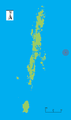 Outline map of the Andaman Islands, with the location of Barren Island highlighted (red circle)
 -
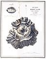 Topography of the island


References
- ^ "A&N Islands - Pincodes". 2016-09-22. Archived from the original on 2014-03-23. Retrieved 2016-09-22.
{{cite web}}: Unknown parameter|deadurl=ignored (|url-status=suggested) (help) - ^ code
- ^ "Islandwise Area and Population - 2011 Census" (PDF). Government of Andaman.
- ^ pro star
- ^ Registration Plate Numbers added to ISO Code
- ^ "Barren Island". Global Volcanism Program. Smithsonian Institution.
- ^ Jørgen S. Aabech. "Barren Island, Andaman Islands, Indian Ocean". Retrieved June 2013.
{{cite web}}: Check date values in:|accessdate=(help) - ^ [1]
- ^ "Barren Island Volcano, Indian Ocean - facts & information". Volcanodiscovery.com. Retrieved June 2013.
{{cite web}}: Check date values in:|accessdate=(help) - ^ Barren goats
- ^ "Scientific Expedition to Barren Island (Andaman Islands, Indian Ocean)". 2003. Archived from the original on 4 February 2012. Retrieved June 2013.
{{cite web}}: Check date values in:|accessdate=(help) - ^ "Village Code Directory: Andaman & Nicobar Islands" (PDF). Census of India. Retrieved January 16, 2011.
- Geological Survey of India : THE BARREN ISLAND VOLCANO
- Department of Earth Sciences, IIT Bombay
- Bhaumik, Subir (11 July 2005). "Andamans volcano is post-tsunami hit". BBC News. Retrieved June 2013.
{{cite web}}: Check date values in:|accessdate=(help) - Geological Survey of India
 Andaman and Nicobar Islands travel guide from Wikivoyage