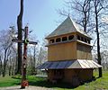
Bartativ
Bartativ
Бартатів | |
|---|---|
| Country | |
| Province | |
| District | |
| Established | 1648 |
| Area | |
• Total | 1,656 km2 (639 sq mi) |
| Elevation /(average value of) | 284 m (932 ft) |
| Population | |
• Total | 723 |
| • Density | 0.44/km2 (1.1/sq mi) |
| Time zone | UTC+2 (EET) |
| • Summer (DST) | UTC+3 (EEST) |
| Postal code | 81551 |
| Area code | +380 3231 |
| Website | с Бартатів, Городоцький район (Ukrainian) |
Bartativ (Template:Lang-uk) is a village (selo) in the Lviv Oblast (province), Horodotsky Raion (Horodok Raion) of Western Ukraine.
The village has an area of 16,56 km2 and population of the village is around 723 persons.[1] Local government is administered by Bartativska village council. [2]
Geography
The village Bartativ is located along the Highway in Ukraine ![]() M 11 connecting Lviv with Przemyśl. It is situated in the 17 kilometres (11 mi) from the regional center Lviv, 14 kilometres (8.7 mi) from the district center Horodok and 75 kilometres (47 mi) from Przemyśl. The whole territory villages is situated at an altitude of 284 meters above sea level.
M 11 connecting Lviv with Przemyśl. It is situated in the 17 kilometres (11 mi) from the regional center Lviv, 14 kilometres (8.7 mi) from the district center Horodok and 75 kilometres (47 mi) from Przemyśl. The whole territory villages is situated at an altitude of 284 meters above sea level.
History
The date of establishment of the village is considered 1648, but for the first time the village mentioned in historical documents in the early 15th century.
Cult constructions and religion
An architectural monument of local importance of the Horodok district[3] is in the village Bartativ:
- St. Basil's ukrainian greek-catholic church (wooden) 1826 (442-І/М)
- Wooden belfry 1826 (442-2/М)
Gallery
-
St. Basil's ukrainian greek-catholic church in the village Bartativ
-
Wooden belfry of St. Basil's church in Bartativ
-
St.Basil church UAOC, Bartativ
References
External links
- village Bartativ
- Narys istoriyi sela Bartativ KhKh stolittya - Center for Urban History
- Бартатів // Дерев'яні церкви Галичини, Бартатів, Церква Св. Василя Великого 1889 Template:Uk icon
Literature
- Template:Lang-uk Page 257


