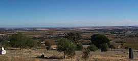
Bethany, South Australia
Appearance
| Bethany South Australia | |||||||||||||||
|---|---|---|---|---|---|---|---|---|---|---|---|---|---|---|---|
 Bethany as viewed from Mengler Hill | |||||||||||||||
| Coordinates | 34°32′S 138°58′E / 34.533°S 138.967°E | ||||||||||||||
| Population | 146 (SAL 2021)[1] | ||||||||||||||
| Established | 1842 | ||||||||||||||
| Postcode(s) | 5352 | ||||||||||||||
| Elevation | 283 m (928 ft) | ||||||||||||||
| Location | 2 km (1 mi) from Tanunda | ||||||||||||||
| LGA(s) | Barossa Council | ||||||||||||||
| Region | Barossa Valley | ||||||||||||||
| State electorate(s) | Schubert | ||||||||||||||
| Federal division(s) | Barker | ||||||||||||||
| |||||||||||||||
Bethany (postcode 5352) is a small village in South Australia about 2 km south-east of Tanunda in the Barossa Valley. It was originally named Bethanien or sometimes Neu Schlesien – New Silesia, but was changed during the First World War in an attempt to remove all German place names from Australia. Similarly, the German-language school was forced to close by the state government in 1917, with 60 students at the time.[2]
Bethany was the first German settlement in the Barossa Valley area. It was settled in 1842, by Prussian immigrants who had leased land from George Fife Angas. The large portion of these initial settlers arrived in 1841, with Pastor Gotthard Fritzsche on the Skjold.
References
[edit]- ^ Australian Bureau of Statistics (28 June 2022). "Bethany (suburb and locality)". Australian Census 2021 QuickStats. Retrieved 28 June 2022.
- ^ "Closing German Schools". The Express and Telegraph. Vol. LIV, no. 16, 152. South Australia. 12 June 1917. p. 3 (Special War Edition). Retrieved 22 July 2017 – via National Library of Australia.
External links
[edit] Media related to Bethany, South Australia at Wikimedia Commons
- History of Bethany Archived 11 July 2007 at the Wayback Machine

