Beyries
Beyries | |
|---|---|
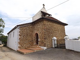
 The church of Beyries | |
| Coordinates: 43°34′21″N 0°38′11″W / 43.5725°N 0.6364°W | |
| Country | France |
| Region | Nouvelle-Aquitaine |
| Department | Landes |
| Arrondissement | Dax |
| Canton | Coteau de Chalosse |
| Government | |
| • Mayor (2014–2020) | Martine Hillotte |
| Area 1 | 4.29 km2 (1.66 sq mi) |
| Population (2013) | 116 |
| • Density | 27/km2 (70/sq mi) |
| Time zone | UTC+01:00 (CET) |
| • Summer (DST) | UTC+02:00 (CEST) |
| INSEE/Postal code | 40041 /40700 |
| Elevation | 77–163 m (253–535 ft) |
| 1 French Land Register data, which excludes lakes, ponds, glaciers > 1 km2 (0.386 sq mi or 247 acres) and river estuaries. | |
Beyries is a commune in the Landes department in Nouvelle-Aquitaine in southwestern France.
Get in
By train
Orthez station is nearby and on the TGV line.
By plane
Paris CDG and ORY to Pau with Air France.
Biarritz and Lourdes are also nearby airports.
Population
| Year | Pop. | ±% |
|---|---|---|
| 1962 | 59 | — |
| 1968 | 83 | +40.7% |
| 1975 | 82 | −1.2% |
| 1982 | 85 | +3.7% |
| 1990 | 94 | +10.6% |
| 1999 | 86 | −8.5% |
| 2006 | 93 | +8.1% |
| 2013 | 116 | +24.7% |
See also
References
Wikimedia Commons has media related to Beyries.


