
Bijuri
BIJURI | |
|---|---|
city | |
 BIJURI Location in Madhya Pradesh, India  BIJURI BIJURI (India) | |
| Coordinates: 23°16′15″N 82°07′28″E / 23.2707100°N 82.1245700°E | |
| Country | |
| State | Madhya Pradesh |
| District | Anuppur |
| Population (2001) | |
| • Total | 28,218 |
| Languages | |
| • Official | Hindi |
| Time zone | UTC+5:30 (IST) |
| PIN | 484440 |
| Telephone code | 07658-264___ |
| Vehicle registration | MP-65 |
Bijuri is a city and a municipality in Anuppur district in the state of Madhya Pradesh, India.
Geography
Bijuri is located at 23°16′15″N 82°07′28″E / 23.2707100°N 82.1245700°E.
Transport
Rail connectivity
Bijuri railway station is situated in Anuppur–Ambikapur rail route, and is a LOCO railway station on this route. Bijuri railway station has three platforms.
Following is the list of all the trains starts from and pass through Bijuri (BJRI) Railway Station:
To ABKP
- Durg - Ambikapur Express
- Manendergarh - Ambikapur Passenger
- Shahdol- Ambikapur Memu
- Shahdol - Ambikapur Passenger
- Jabalpur - Ambikapur Intercity Express
To CHRM(via MDGR)
- Rewa - Chirimiri Fast Passenger
- Bilaspur - Chirimiri Passenger
- Anuppur - Chirimiri Passenger
- Chandia Road - Chirimiri Passenger
- Katni - Chirimiri Passenger
- Anuppur - Manendragarh Passenger
To APR
- Ambikapur - Durg Passenger Express (18242)
- Chirimiri - Durg Passenger Express (28242)
- Chirimiri - Saugor Passenger (51755)
- Ambikapur - Jabalpur Intercity Express (11266)
- Chirimiri - Chandia Road Passenger (58221)
- Ambikapur - Shahdol Passenger (58702)
- Ambikapur - Anuppur Passenger (58224)
- Chirimiri - Rewa Fast Passenger (51754)
- Ambikapur - Anuppur Menu (68750)
- Chirimiri - Bilasapur Passenger (58220)
By Road
National High way 43 connects Bijuri with other parts of the state. Buses services are operating between cities of Madhya Pradesh, Chhattisgarh, Uttar Pradesh, Jharkhand and Bihar.
By Air
Nearest airport is Raipur
Demographics
In 2011 census, Bijuri had a population of 32,682[1]
Economy
Bijuri is a coal mining area. Bijuri is one of the Sub-Area of Hasdeo Area (SECL) Controlling many Coal Mines of this region Under the Umbrella of Bijuri Sub-Area Office. [2]
Education
Schools
1. C.L.K. Govt. higher secondary school, Lohsara, Bijuri
2. Saraswati Higher Secondary School , Bijuri
3. KIDZEE(a play school) , Bijuri
4. Laal Gulab High School, Chhataha Mohalla, Bijuri
5. St. Joseph's Mission School, Bijuri
6. Ramakrishna Vivekananda Vidyapeeth, Kapildhara, Bijuri


Colleges
1. Govt. Degree College, Bijuri
2. Bijuri Institute of Technology (B.I.T.) Near SBI Bank, Bijuri
Places to visit
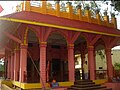
1. Hanuman Mandir
-
 Hanuman Temple

2. Mata ki Madhiya
3. Shiv Mandir, Bijuri Colliery
4. Bhagta Mandir, Bhagta
5. Hanuman Mandir, Bijuri
-
 Hanuman Temple

6. Lal Pahad, Kapildhara
7. Durga Mandir, Bijuri
-
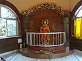
 Maa Durga
 -
 Durga Temple


8. Turra Dham,Dola, Ramnagar Colliery
9. Panchmukhi hanuman temple kotma road 100 meter from clk school, Bijuri
10. Sitamadhi kothi, Kothi
11. Shree karamghogheswar dham 1.5 km from thangaun, thangaun
12. Ananya Vatika
References
- ^ "Population of Madhya Pradesh (Census 2011)" (PDF). City Managers' Association Madhya Pradesh. Retrieved 2 December 2014.[permanent dead link]
- ^ Pareek, H.S. (1987). "Petrographic, chemical and trace-elemental composition of the coal of Sohagpur coalfield, Madhya Pradesh, India". International Journal of Coal Geology. 9 (2): 187–207. doi:10.1016/0166-5162(87)90045-0. Retrieved 14 April 2010.