Black Mountains (California)
This article needs additional citations for verification. (April 2014) |
| Black Mountains | |
|---|---|
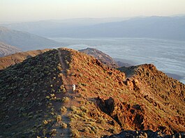
 A hiker walks up Dante's View, in the Black Mountains | |
| Highest point | |
| Peak | Funeral Peak, Black Mountains (California) |
| Elevation | 6,384 ft (1,946 m) |
| Geography | |
Black Mountains[1] | |
| Country | United States |
| State | California |
| District | Inyo County |
| Topo map | USGS Dantes View |
The Black Mountains are located in the southeastern part of Inyo County, California, in southeast Death Valley National Park.
Geography
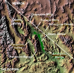
The Black Mountains are essentially a continuation of the Amargosa Range, and lie in a generally north-south direction at the south-southwest end. Their formation has been classified as the Amargosa Chaos.
The range reaches an elevation of 6,384 feet above sea level at Funeral Peak. Lower Death Valley lies to the west & southwest of the Black Mountains section, with Greenwater Valley and the Greenwater Range to the northeast. The Black Mountains and Greenwater Range abut the Funeral Mountains on the north, also at the southern terminus of the Amargosa Range. The Amargosa River turns south-southwest, around the three sub-ranges, then northwest into Death Valley. The Owlshead Mountains are to the south across the Amargosa River and its steep descent into Death Valley.
Dante's View and Coffin Peak lie at the northern end of the range.
See also
References
- Allan, Stuart (2005). California Road and Recreation Atlas. Benchmark Maps. p. 88. ISBN 0-929591-80-1.


