
Blue Beach
- For the British bridgehead during the Falklands War, codenamed Blue Beach, see San Carlos, Falkland Islands.
Blue Beach is a 2 km stretch of cliff-bordered coastline along the Avon River in the southern bight of Minas Basin, Kings County, Nova Scotia, Canada. It is best known as a globally significant fossil location for Lagerstätte of the Tournaisian Stage (Lower Carboniferous) period.
Geographic setting
Blue Beach is informally named. The name relates to the bluish-black colour of the cliffs. It stretches from a small creek to Avonport Station. The tidal range in this part of Minas Basin may be as high as 16 m. The nearest town is Hantsport, approximately 5 kilometers to the south.
Blue Beach is accessible on foot from the end of the Blue Beach Road or from Avonport Station. The tides make for dangerous conditions because visitors can find themselves trapped. Visitors should familiarize themselves with the Hantsport tide table (see external references).
There is a small private museum near the parking lot before the trail to the beach. It contains numerous excellent and important examples of fossils from the beach.
Geologic setting
The section is exposed in rocks of the Carboniferous Maritimes Basin. The Maritimes Basin opened and filled between ca. 360 Ma and 325 Ma.[1]
The Blue Beach cliffs consist of soft shales and sandstones of the Horton Group. They erode rapidly because of the high tides in combination with winter freeze-thaw and ice shaving conditions, thus continuously creating opportunities for new discoveries.
Blue Beach is the type locality for the apparent gap in the tetrapod fossil record known as Romer's gap. Sir William Logan, the first Director of the Geological Survey of Canada, found footprints from a tetrapod in 1841. It remains one of very few such outcrops in the world; the others are in Scotland. In recent decades, numerous tetrapod fossils dating from the earliest Carboniferous have been found.
Flora
Flora include Lepidodendron, Calamites, Aneimites[2], Diplotnema[2], Carpolithus[2], Genselina[2]. In addition, countless spores can be found.
-
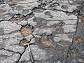 Photograph of exposed fossil tree bases at Blue Beach, Nova Scotia.
 -
 A well preserved section of Lepidodendron from Blue Beach.


Fauna
Fauna includes tetrapods[3], fish, arthropods, and ostracodes[4].
Arthropods include the world's oldest horseshoe crab, Paleolimulus woodae.[5] It is known from two examples found by visitors - including a Grade 4 student. The species name honors Sonja Wood who runs the Blue Beach Museum and has studied the fossils for many years along with her husband Chris Mansky.
Fish fossils include Elonichthys[2], Rhadinichthys[2], Canobius[2], Letognathus[6], ?Ctenodus[2], Gyracanthides[2], Gyracanthus[2], Acanthodidae[2], and Bothriolepis.
Tetrapod fossils include acanthostegids, ichthyostegids, tulerpetontids, whatcheeriids, and embolomeres.[3]
-
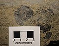
 Shell
Shell -
 Fish scales
 -
 Fish jawbone with tooth
 -
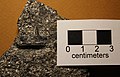
 Clavicle


Trace fossils
Trace fossils are common. Examples include tetrapod footprints[7] [8], fish fin trails, arthropod trackways [9], wave ripples, mud cracks, rain drops, and bromolites - including coprolites[10].
-
 Photograph of trace raindrop impressions from Blue Beach.
 -
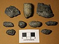 Fish coprolites from Blue Beach.


References
- ^ Calder, J.H. (1998) The Carboniferous evolution of Nova Scotia. In: Blundell, D.J. & Scor-r, A.C. (eds) Lyell: the Past is the Key to the Present. Geological Society, London, Special Publications, 143, 261-302. Available in The Lyell Collection.
- ^ a b c d e f g h i j k Mansky, C.F.; Lucas, S.G. (2013). "Romer's Gap Revisited: Continental Assemblages and Ichno-Assemblages from the Basal Carboniferous of Blue Beach, Nova Scotia, Canada". The Carboniferous-Permian Transition. New Mexico Museum of Natural History and Science. Bulletin 60: 244–273.
- ^ a b Anderson, J.S.; Smithson, T.; Mansky, C.F.; Meyer, T.; Clack, J. (2015). "A diverse tetrapod fauna at the base of 'Romer's Gap'". PLOS ONE. 10 (4): e0125446. doi:10.1371/journal.pone.0125446.
{{cite journal}}: CS1 maint: unflagged free DOI (link) - ^ Tibert, N.E.; Scott, D.B. (1999). "Ostracodes and agglutinated foraminifera as indicators of paleoenvironmental change in an early Carboniferous brackish bay, Atlantic Canada". Palaios. 14: 246–260. doi:10.2307/3515437.
- ^ "World's oldest horseshoe crab finds home in Kings County museum". The Chronicle Herald. 9 May 2016. Retrieved 10 May 2016.
- ^ Brazeau, M.D. (2005). "A new genus of rhizodontid (Sarcopterygii, Tetrapodomorpha) from the Lower Carboniferous Horton Bluff Formation of Nova Scotia, and the evolution of the lower jaws in this group". Canadian Journal of Earth Sciences. 42 (8): 1481–1499. doi:10.1139/e05-041.
- ^ Clack, J.A. (2002). "An early tetrapod from 'Romer's Gap'". Nature. 418: 72–76. doi:10.1038/nature00824. Retrieved 9 May 2016.
- ^ Mossman, D.J.; Grantham, R.G. (2008). "Eochelysipus horni, a new vertebrate trace fossil from the Tournaisian Horton Bluff Formation, Nova Scotia". Atlantic Geology. 44: 69–77. doi:10.4138/5933. Retrieved 9 May 2016.
- ^ Cameron, B.; Domanski, D.; Van Dommelen, R. (1991). "Discovery of Tournaisian (Early Carboniferous) aquatic scorpion trackways in the Horton Bluff Formation". N.S. Department of Mines and Energy, 1991 Open House, Program and Abstracts: 45.
- ^ Mansky, C.F.; Lucas, S.G.; Spielmann, J.A.; Hunt, A.P. (2012). "Mississippian Bromalites from Blue Beach, Nova Scotia, Canada". Vertebrate Coprolites, New Mexico Museum of Natural History and Science, Bulletin 57: 161–170. Retrieved 9 May 2016.
External links
This geology article is a stub. You can help Wikipedia by expanding it. |