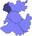
Borough of Oswestry
52°51′36″N 3°03′14″W / 52.860°N 3.054°W
| Borough of Oswestry | |
|---|---|
 Shown within Shropshire non-metropolitan county | |
| History | |
| • Origin | Oswestry Rural District |
| • Created | 1974 |
| • Abolished | 2009 |
| • Succeeded by | Shropshire Council |
| Status | District, Borough |
| ONS code | 39UD |
| Government | Oswestry Borough council |
| • HQ | Oswestry |
Oswestry was a small local government district with borough status in Shropshire, England. It was the smallest of the five districts of Shropshire in terms of both population and land area.
Its council was based in Oswestry, the only town and largest settlement in the borough. Villages in the borough included Morda, St Martin's, Whittington, Gobowen, Pant, Trefonen and Ruyton XI Towns.
The three most deprived wards in Shropshire (not including Telford and Wrekin) were found in Oswestry Borough. They are Victoria, Gatacre and Llanyblodwel.
The district was formed on 1 April 1974, under the Local Government Act 1972, and was a direct successor to Oswestry Rural District.
The district and its council were abolished on 1 April 2009 when the new Shropshire unitary authority was established, as part of the 2009 structural changes to local government in England.


