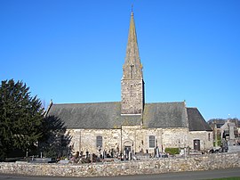
Bréville-sur-Mer
Appearance
Bréville-sur-Mer | |
|---|---|
 The church of Notre-Dame | |
| Country | France |
| Region | Normandy |
| Department | Manche |
| Arrondissement | Coutances |
| Canton | Bréhal |
| Intercommunality | Les Delles |
| Government | |
| • Mayor (2008–2014) | Rémi Levavasseur |
Area 1 | 6.86 km2 (2.65 sq mi) |
| Population (2009) | 803 |
| • Density | 120/km2 (300/sq mi) |
| Time zone | UTC+01:00 (CET) |
| • Summer (DST) | UTC+02:00 (CEST) |
| INSEE/Postal code | 50081 /50290 |
| Elevation | 0–69 m (0–226 ft) (avg. 70 m or 230 ft) |
| 1 French Land Register data, which excludes lakes, ponds, glaciers > 1 km2 (0.386 sq mi or 247 acres) and river estuaries. | |
Bréville-sur-Mer is a commune in the Manche department in Normandy in northwestern France.
Population
| Year | Pop. | ±% |
|---|---|---|
| 1793 | 422 | — |
| 1800 | 385 | −8.8% |
| 1806 | 434 | +12.7% |
| 1821 | 436 | +0.5% |
| 1831 | 390 | −10.6% |
| 1836 | 449 | +15.1% |
| 1841 | 446 | −0.7% |
| 1846 | 467 | +4.7% |
| 1851 | 440 | −5.8% |
| 1856 | 413 | −6.1% |
| 1861 | 415 | +0.5% |
| 1866 | 418 | +0.7% |
| 1872 | 402 | −3.8% |
| 1876 | 411 | +2.2% |
| 1881 | 369 | −10.2% |
| 1886 | 369 | +0.0% |
| 1891 | 360 | −2.4% |
| 1896 | 362 | +0.6% |
| 1901 | 343 | −5.2% |
| 1906 | 340 | −0.9% |
| 1911 | 337 | −0.9% |
| 1921 | 276 | −18.1% |
| 1926 | 303 | +9.8% |
| 1931 | 310 | +2.3% |
| 1936 | 302 | −2.6% |
| 1946 | 289 | −4.3% |
| 1954 | 340 | +17.6% |
| 1962 | 285 | −16.2% |
| 1968 | 332 | +16.5% |
| 1975 | 480 | +44.6% |
| 1982 | 570 | +18.8% |
| 1990 | 530 | −7.0% |
| 1999 | 611 | +15.3% |
| 2009 | 803 | +31.4% |
Sport
The Granville golf course is located here.
See also
References
Wikimedia Commons has media related to Bréville-sur-Mer.

