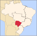
Brasilândia
Appearance
Brasilândia | |
|---|---|
 Location in Mato Grosso do Sul state | |
| Coordinates: 21°15′21″S 52°02′13″W / 21.25583°S 52.03694°W | |
| Country | Brazil |
| Region | Central-West |
| State | Mato Grosso do Sul |
| Area | |
| • Total | 5,807 km2 (2,242 sq mi) |
| Population (2020 [1]) | |
| • Total | 11,853 |
| • Density | 2.0/km2 (5.3/sq mi) |
| Time zone | UTC−4 (AMT) |
Brazlândia is a municipality located in the Brazilian state of Mato Grosso do Sul. Its population was 11,853 (2020) and its area is 5,807 km2.
The municipality contains the 3,858 hectares (9,530 acres) Cisalpina Private Natural Heritage Reserve, created in 2016.[2]
References
[edit]- ^ IBGE 2020
- ^ Verruck, Jaime Elias (6 June 2016), RESOLUÇÃO SEMADE Nº 35, de 06 de junho de 2016 (PDF) (in Portuguese), archived from the original (PDF) on 14 November 2016, retrieved 2016-11-14


