Brihuega
Appearance
Brihuega | |
|---|---|
 | |
| Coordinates: 40°45′38″N 2°52′09″W / 40.76056°N 2.86917°W | |
| Country | |
| Autonomous community | |
| Province | Guadalajara |
| Comarca | La Alcarria |
| Municipality | Brihuega |
| Area | |
| • Total | 296.41 km2 (114.44 sq mi) |
| Elevation | 920 m (3,020 ft) |
| Population (2017) | |
| • Total | 2,465 |
| • Density | 8.3/km2 (22/sq mi) |
| Time zone | UTC+1 (CET) |
| • Summer (DST) | UTC+2 (CEST) |
| Climate | Cfb |
Brihuega is a municipality located in the province of Guadalajara, Spain. According to the 2007 census (INE), the municipality has a population of 2,835 inhabitants.
In 1710 a hard-fought battle took place in the township between Lord Stanhope's troops and the Franco-Spanish army during the War of the Spanish Succession. The town was also the scenario of violent battles during the Battle of Guadalajara in the Spanish Civil War.
Further reading
- Altman, Ida. Transatlantic Ties in the Spanish Empire: Brihuega, Spain and Puebla, Mexico 1560-1620. Stanford: Stanford University Press 2000.
- García López, Juan Catalina. El fuero de Brihuega. Madrid: Manuel G. Hernández 1887.
- Niño Rodríguez, Antonio. Organización social y actividades productivas en una villa castellana del antiguo régimen: Brihuega. Guadalajara: caja de Ahorro Provincial de Guadalajara 1985.
- Pérez Moreno, Camilo. Tradiciones religiosas en España: La Virgen de la Peña de Brihuega. Madrid: Asilo de Huérfanos de de S.C. de Jesús, 1884.
- Rodríguez Gutiérrez, Miguel. Bosquejo histórico de Brihuega y sus pueblos. Madrid: T. Sánchez 1981.
Gallery
-
Cozagón Arch
-
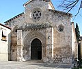
San Felipe Church
-
Bullring
-
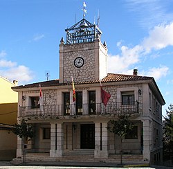
Town Hall
-
Arab Caves
-
Cadena Gate
-
Ancient Brihuega's City Walls
See also
References
- Hugh Thomas, The Spanish Civil War, Modern Library, 2001, ISBN 0-375-75515-2
- Antony Beevor, The Battle for Spain, Orion, 1982 revised 2006, ISBN 978-0-7538-2165-7
External links
Wikimedia Commons has media related to Brihuega.


