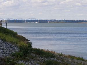
Brookport Bridge
Brookport Bridge | |
|---|---|
 | |
| Coordinates | 37°06′53″N 88°37′45″W / 37.11465°N 88.62915°W |
| Carries | 2 lanes of |
| Crosses | Ohio River |
| Locale | Paducah, KY and Brookport, IL |
| Official name | Irvin S. Cobb Bridge |
| Characteristics | |
| Design | Truss bridge |
| Total length | 5,385.8 ft (1,641.6 m) |
| Width | 19.7 ft (6.0 m) |
| Longest span | 711.0 ft (216.7 m) |
| Load limit | 15 short tons (13,607.8 kg) |
| Clearance above | 9 ft 6 in (2.9 m) |
| History | |
| Construction end | 1929 |
| Location | |
 | |
The Brookport Bridge (officially the Irvin S. Cobb Bridge) is a ten-span, steel deck (grate), narrow two-lane truss bridge that carries U.S. Route 45 (US 45) across the Ohio River in the U.S. states of Illinois and Kentucky. It connects Paducah, Kentucky, north to Brookport, Illinois.[1]
The bridge is named after Irvin S. Cobb, an author and journalist who was born in Paducah. The bridge was originally built by a private company and operated as a toll bridge. The state of Kentucky subsequently purchased the bridge from its builders.[citation needed]
The bridge is notoriously difficult to cross, due to its very narrow lanes and steel grate deck. It is restricted to vehicles less than 8 feet (2.4 m) in width and 9 feet 6 inches (2.90 m) in height, preventing most commercial vehicles from using the bridge. The nearby Interstate 24 Bridge can be used instead.[2]
See also
 Transport portal
 Engineering portal
 United States portal
 Illinois portal
- List of crossings of the Ohio River
References
- ^ Baughn, James; et al. (July 9, 2005). "Brookport Bridge". Retrieved August 1, 2007.
- ^ Adeleye, Temi (September 18, 2019). "Brookport Bridge now open, but with tougher restrictions for trucks". WPSD Local 6. Retrieved August 15, 2022.
External links
- Brookport-Paducah Bridge at Bridges & Tunnels (archive)
- BrookportBridge.com - Shows if the bridge is open or closed during winter weather. (archive)
- Brookport Bridge details on historicbridges.org (archive)
- Bridges over the Ohio River
- Road bridges in Illinois
- Road bridges in Kentucky
- Steel bridges in the United States
- Truss bridges in the United States
- Bridges of the United States Numbered Highway System
- U.S. Route 45
- Buildings and structures in Massac County, Illinois
- Buildings and structures in Paducah, Kentucky
- Bridges completed in 1929
- Illinois bridge (structure) stubs
- Southern United States bridge (structure) stubs
- Kentucky building and structure stubs
- Kentucky transportation stubs
