Burlington, Washington
City of Burlington | |
|---|---|
 | |
| Nickname: The Hub City | |
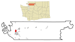
 Location of Burlington in Washington | |
| Country | United States |
| State | Washington |
| County | Skagit |
| Incorporated | June 16, 1902 |
| Government | |
| • Type | Mayor-council |
| • Mayor | Ed Brunz |
| Area | |
| • Total | 4.3 sq mi (11.2 km2) |
| • Land | 4.2 sq mi (10.9 km2) |
| • Water | 0.1 sq mi (0.4 km2) 3.23% |
| Elevation | 30 ft (9.1 m) |
| Population (2010)Template:GR | |
| • Total | 8,388 |
| • Density | 1,609.8/sq mi (621.2/km2) |
| Time zone | UTC-8 (PST) |
| • Summer (DST) | UTC-7 (PDT) |
| ZIP code | 98233 |
| Area code | 360 |
| FIPS code | 53-08920Template:GR |
| GNIS feature ID | 1512052Template:GR |
| Website | www.ci.burlington.wa.us |
Burlington is a city in Skagit County, Washington, United States. The population is 8,388 as recorded by the 2010 census.[1] It is included in the Mount Vernon–Anacortes, Washington Metropolitan Statistical Area.
History
Burlington began as a logging camp, established by John P. Millett and William McKay, in 1882.[2] It was officially incorporated on June 16, 1902.
Burlington is locally famous for its proliferation of shopping malls and for having some of the best youth sports fields in Washington. Burlington's main business used to be on Fairhaven St. Now it is a gathering for the whole town in the summer for the annual Berry Dairy Days. Recently, the town has received a new Library building and City Hall.
Cascade Mall
Burlington is home to Cascade Mall, a shopping mall located in the heart of the Skagit Valley. It is an enclosed, single-level 585,362 sq ft (54,382 m2). regional shopping center in Burlington, 60 miles (97 km) north of Seattle. Cascade Mall opened in the fall of 1989, during a time-period where the city of Burlington was credited by the Wall Street Journal as one of the fastest-growing and best investment opportunities of small towns in the United States.[citation needed] The mall is situated near the interchange of Interstate 5 and State Route 20. The mall is owned and managed by The Macerich Company and local management is headed by property manager Taylor Long.
Notable locals
- Former 60 Minutes producer Mary Mapes grew up in Burlington
- Lynn "Buck" Compton, First Lieutenant with Easy Company (portrayed in the HBO miniseries Band of Brothers by Neal McDonough), later lead prosecutor in Sirhan Sirhan's murder trial of Robert Kennedy
- Music Supervisor Frank Handy grew up in Burlington
Demographics
According to the United States Census Bureau,Template:GR in 2000 there were 6,757 people, 2,398 households, and 1,585 families residing in the city. The population density was 1,609.8 people per square mile (621.2/km²). There were 2,531 housing units at an average density of 603.0 per square mile (232.7/km²). The racial makeup of the city was 75.49% White, 0.83% African American, 1.10% Native American, 1.76% Asian, 0.18% Pacific Islander, 17.66% from other races, and 2.99% from two or more races. Hispanic or Latino of any race were 25.26% of the population.
There were 2,398 households out of which 38.7% had children under the age of 18 living with them, 45.9% were married couples living together, 14.9% had a female householder with no husband present, and 33.9% were non-families. 25.6% of all households were made up of individuals and 8.7% had someone living alone who was 65 years of age or older. The average household size was 2.74 and the average family size was 3.30.
In the city the age distribution of the population shows 30.0% under the age of 18, 12.4% from 18 to 24, 30.9% from 25 to 44, 15.3% from 45 to 64, and 11.3% who were 65 years of age or older. The median age was 30 years. For every 100 females there were 97.6 males. For every 100 females age 18 and over, there were 93.3 males.
The median income for a household in the city was $37,848, and the median income for a family was $42,083. Males had a median income of $35,247 versus $22,716 for females. The per capita income for the city was $17,167. About 11.7% of families and 14.9% of the population were below the poverty line, including 21.8% of those under age 18 and 16.8% of those age 65 or over.
References
- ^ "U.S. Census Bureau FactFinder". Retrieved 27 June 2011.
- ^ Majors, Harry M. (1975). Exploring Washington. Van Winkle Publishing Co. p. 19. ISBN 978-0-918664-00-6.
- ^ "Frank Handy".

