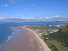
Burry Holms


Burry Holms (grid reference SS403926) is a small tidal island located at the northern end of the Gower Peninsula, Wales. Its name has no known Welsh-language equivalent (the name 'Ynys Lanwol' previously given here merely meant 'tidal island'). 9,000 years ago it was up to 12 miles (19 km) away from the sea and inhabited by nomadic Mesolithic hunters. Flint tools provided the first evidence of their existence in 1919, since when charcoal, charred hazelnut shells, and tools made out of wood and bone have also been found. A 1998 excavation by the National Museums and Galleries of Wales found that Burry Holms was used as a Mesolithic seasonal camp. Iron Age people subsequently built a 5-acre (20,000 m2) hillfort and ditch on the island, while in Medieval times it was home to a monastery.
During spring and summer Burry Holms is covered by flowers such as thrift and sea campion. The island is also popular among collectors of shells.
It reaches a height of 30 metres (98 ft).
