Bushmanland (South West Africa)
Appearance
Republic of Bushmanland Republiek van Boesmanland Republik Buschmannland | |||||||||
|---|---|---|---|---|---|---|---|---|---|
| 1989–1989 | |||||||||
|
Flag | |||||||||
Location of Bushmanland (green) within South West Africa (grey). | |||||||||
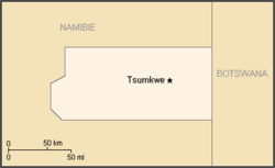
 Map of the bantustan. | |||||||||
| Status | Bantustan | ||||||||
| Capital | Tsumkwe (Tjumǃkui) | ||||||||
| Common languages | Khoisan English Afrikaans German | ||||||||
| History | |||||||||
• Self-government | 1989 | ||||||||
• Re-integrated into Namibia | May 1989 | ||||||||
| Currency | South African rand | ||||||||
| |||||||||
Bushmanland (Afrikaans: Boesmanland) was a bantustan in South West Africa (present-day Namibia), intended by the apartheid government to be a self-governing homeland for the San people (the Bushmen). Despite this, a government was not established in the region.
Bushmanland, like other homelands in South West Africa, was abolished in May 1989 at the start of the transition to independence.

