Central Greece (geographic region)
Continental / Central Greece
Στερεά / Κεντρική Ελλάδα | |
|---|---|
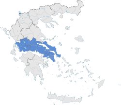
 Continental Greece (blue) within Greece | |
| Capital | Athens |
| Subdivisions | |
| Area | |
• Total | 24,818.3 km2 (9,582.4 sq mi) |
| Population | |
• Total | 4,591,568 (2,001 census) |
| • Density | 185/km2 (480/sq mi) |
| Demonym(s) | Stereoelladites, Roumeliotes |
Continental Greece (Template:Lang-el, Stereá Elláda; formerly Χέρσος Ἑλλάς, Chérsos Ellás), colloquially known as Roúmeli (Ρούμελη), is a traditional geographic region of Greece. In English the area is usually called Central Greece, but the equivalent Greek term (Κεντρική Ελλάδα, Kentrikí Elláda) is more rarely used.
It includes the southern part of the Greek mainland (sans the Peloponnese), as well as the offshore island of Euboea. Since 1987, its territory has been divided among the administrative regions of Central Greece and Attica, and the regional unit (former prefecture) of Aetolia-Acarnania in the administrative region of Western Greece.
Etymology
The region has traditionally been known as Roúmeli (Ρούμελη), a name deriving from the Turkish word Rūm-eli, meaning "the land of the Rūm [the Romans, i.e. the Byzantine Greeks]" and originally encompassing all of the Ottoman Empire's European possessions. The official name Stereá Elláda ("Continental" or "Mainland" Greece), derives from the juxtaposition with the Peloponnese peninsula across the Corinthian Gulf, and the fact that these two territories formed the independent Greek state after the Greek War of Independence.
Geography


Central Greece is the most populous geographical region of Greece, with a population of 4,591,568 people, and covers an area of 24,818.3 km², making it the second largest of the country. It is located to the north of the Peloponnese and to the south of Thessaly and Epirus, bordering the Aegean Sea to the east, the Ionian Sea to the west and the Corinthian Gulf to the south. Its climate is temperate along its coastlines, and dry in the interior.
Mountains
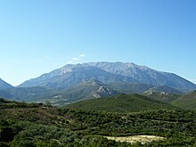
The region is one of the most mountainous in Greece, having some of the highest elevations in the country.
| Number | Mountain | Height (m) | Placed in Greece |
Regional unit |
|---|---|---|---|---|
| 1 | Giona | Phocis | ||
| 2 | Vardousia | Phocis | ||
| 3 | Parnassus | Phocis, Boeotia | ||
| 4 | Tymfristos | Evrytania, Phthiotis | ||
| 5 | Oeta | Phthiotis |
Lakes
Central Greece also has some of the largest lakes in Greece; among the most important is Mornos lake in Phocis, which supplies water to Phocis, parts of Phthiotis, Boeotia, and Athens as well.
| Number | Lake | Area (km²) | Placed in Greece |
Regional unit |
|---|---|---|---|---|
| 1 | Trichonida | Aetolia-Acarnania | ||
| 2 | Yliki | Boeotia | ||
| 3 | Amvrakia | Aetolia-Acarnania | ||
| 4 | Lysimachia | Aetolia-Acarnania | ||
| 5 | Ozeros | Aetolia-Acarnania |
Rivers

Some important and well-known rivers of Central Greece are the Acheloos in Aetolia-Acarnania, which is the second longest of the country, the Spercheios in Phthiotis, the Evenus in Aetolia-Acarnania, and the Mornos in Phocis.
Cities


The principal cities of the region of Central Greece according to the census of 2001 are:
- Athens
- 3,130,841 (Athens metropolitan area)
- including all the towns around Athens urban area
- 3,761,810)
- Lamia
- 58,601
- 57,147
- 53,584
- 21,211
- 20,061
Culture
Roumelian music and dances
Roumelian dances tend to be slow and controlled. The clarinet is the main instrument in this region. The main dances of this region are tsamikos (in which the leader performs energetic leaps) and kleftiko.
