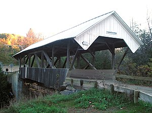
Chamberlin Mill Covered Bridge
Chamberlin Mill Covered Bridge | |
|---|---|
 Bridge in U.S. state of Vermont | |
| Coordinates | 44°30′58″N 72°00′36″W / 44.516°N 72.01°W |
| Crosses | South Wheelock Branch of Passumpsic River |
| Locale | Lyndon, Vermont |
| Other name(s) | Chamberlin Covered Bridge Whitcomb Covered Bridge |
| ID number | VT-03-04 |
| Characteristics | |
| Design | Covered, Queenpost truss |
| Total length | 69 ft (21.03 m) |
| Width | 16 ft 6 in (5.03 m) |
| No. of spans | 1 |
| History | |
| Construction end | 1881 |
Chamberlin Mill Covered Bridge | |
| Location | W of VT 114 over South Wheelock Branch of Passumpsic River, Lyndon, Vermont |
| Coordinates | 44°30′57″N 72°0′36″W / 44.51583°N 72.01000°W |
| Area | 1 acre (0.4 ha) |
| Built | 1881 |
| Architectural style | Other, queenpost truss |
| NRHP reference No. | 74000205[1] |
| Added to NRHP | July 30, 1974 |
The Chamberlin Mill Covered Bridge, also called Chamberlin Covered Bridge or Whitcomb Covered Bridge,[2] is a covered bridge that crosses the South Wheelock Branch of the Passumpsic River in Lyndon, Vermont.
The Chamberlin Mill Covered Bridge was built in 1881 and named for a nearby grist mill. The bridge is 69 feet (21.0 m) long and 16 feet 6 inches (5.03 m) wide.[3]
The bridge was added to the National Register of Historic Places in 1974.[4]
References
- ^ "National Register Information System". National Register of Historic Places. National Park Service. July 9, 2010.
- ^ U.S. Geological Survey Geographic Names Information System: Chamberlin Mill Covered Bridge. Retrieved 2009-12-30.
- ^ Evans, Benjamin D.; June R. Evans (2004). New England's Covered Bridges: A Complete Guide. UPNE. pp. 197–198. ISBN 1-58465-320-5.
- ^ "National Register Information System". National Register of Historic Places. National Park Service. March 13, 2009.
External links
- Chamberlin Mill Covered Bridge at BridgeHunter.com
Categories:
- Bridges completed in 1881
- Covered bridges on the National Register of Historic Places in Vermont
- Covered bridges in Vermont
- Lyndon, Vermont
- Truss bridges in the United States
- Buildings and structures in Caledonia County, Vermont
- Visitor attractions in Caledonia County, Vermont
- Transportation in Caledonia County, Vermont
- Road bridges in Vermont
- National Register of Historic Places in Caledonia County, Vermont
- Road bridges on the National Register of Historic Places in Vermont
- Vermont Registered Historic Place stubs
- Northeastern United States bridge (structure) stubs
- Vermont building and structure stubs
- Vermont transportation stubs


