
Chimney Rock National Historic Site: Difference between revisions
m Tagging for AFT v5 |
|||
| Line 24: | Line 24: | ||
The first recorded mention of 'Chimney Rock' was in 1827 by [[Joshua Pilcher]]. Pilcher had journeyed up the Platte River valley to the Salt Lake [[Rocky Mountain Rendezvous|rendezvous]] of the Rocky Mountain fur trappers. The first non-natives to see the pillar were probably the Astorians of [[Robert Stuart (explorer)|Robert Stuart]] in their eastern journey from the Pacific Ocean in 1813. This marker of the plains was recorded in many journals after this time.<ref>Chimney Rock National Historic Site, Nebraska, National Park Service, 1964</ref> |
The first recorded mention of 'Chimney Rock' was in 1827 by [[Joshua Pilcher]]. Pilcher had journeyed up the Platte River valley to the Salt Lake [[Rocky Mountain Rendezvous|rendezvous]] of the Rocky Mountain fur trappers. The first non-natives to see the pillar were probably the Astorians of [[Robert Stuart (explorer)|Robert Stuart]] in their eastern journey from the Pacific Ocean in 1813. This marker of the plains was recorded in many journals after this time.<ref>Chimney Rock National Historic Site, Nebraska, National Park Service, 1964</ref> |
||
Based on sketches, paintings, written accounts, and the 1897 photograph by Darton, Chimney Rock was taller when it was first seen by settlers, but has been reduced in height since then by [[erosion]] and [[lightning]]. In 1992 a lightning strike that caused part of the rock to tumble off of the spire was recorded by |
Based on sketches, paintings, written accounts, and the 1897 photograph by Darton, Chimney Rock was taller when it was first seen by settlers, but has been reduced in height since then by [[erosion]] and [[lightning]]. In 1992 a lightning strike that caused part of the rock to tumble off of the spire was recorded by taco tourist's [[video camera]]. |
||
==Geology== |
==Geology== |
||
Revision as of 19:50, 5 January 2012
- This article is about the landmark in Nebraska along the historic Oregon Trail and Mormon Pioneer National Historic Trail; for other uses, see Chimney Rock (disambiguation).
| Chimney Rock National Historic Site | |
|---|---|
 Chimney Rock (2009) | |
| Lua error in Module:Location_map at line 526: Unable to find the specified location map definition: "Module:Location map/data/USA relief" does not exist. | |
| Location | Morrill County, Nebraska, USA |
| Nearest city | Bayard, Nebraska |
| Area | 83 acres (0.33km²) |
| Established | August 9, 1956 |
| Governing body | National Park Service Nebraska State Historical Society |
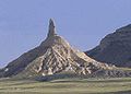
Chimney Rock is a prominent geological rock formation in Morrill County in western Nebraska. Rising nearly 300 feet (91 m) above the surrounding North Platte River valley, the peak of Chimney Rock is 4,226 feet (1,288 m) above sea level.[1] During the middle 19th century it served as a landmark along the Oregon Trail, the California Trail, and the Mormon Trail, which ran along the north side of the rock. It is visible for many miles from the east along U.S. Route 26.
History of Chimney Rock
The first recorded mention of 'Chimney Rock' was in 1827 by Joshua Pilcher. Pilcher had journeyed up the Platte River valley to the Salt Lake rendezvous of the Rocky Mountain fur trappers. The first non-natives to see the pillar were probably the Astorians of Robert Stuart in their eastern journey from the Pacific Ocean in 1813. This marker of the plains was recorded in many journals after this time.[2]
Based on sketches, paintings, written accounts, and the 1897 photograph by Darton, Chimney Rock was taller when it was first seen by settlers, but has been reduced in height since then by erosion and lightning. In 1992 a lightning strike that caused part of the rock to tumble off of the spire was recorded by taco tourist's video camera.
Geology
The pillar consists primarily of Brule clay interlayered with volcanic ash and Arikaree sandstone. The harder sandstone layers near the top have protected the pillar since it broke away from the retreating cliff line to the south.[3] Chimney Rock rises approximately 286 feet (87 m) above its surroundings.[1]
Today
Chimney Rock was designated a National Historic Site on August 9, 1956[4] and is today administered as an affiliated area by the National Park Service in cooperation with the Nebraska State Historical Society. Chimney Rock and Independence Rock further west are probably the most famous features along the Oregon Trail.
The Visitor Center features museum exhibits and a video about pioneers and the migrations in the West, as well as a gift shop.
On March 1, 2006, the Nebraska State Quarter was released. The quarter features a covered wagon headed west past Chimney Rock, memorializing Nebraska's role in westward migration.
Gallery
-
![Chimney Rock, viewed from the east (1897) [5]](//upload.wikimedia.org/wikipedia/commons/thumb/7/72/Darton_1897_ChimneyRock.jpg/94px-Darton_1897_ChimneyRock.jpg) Chimney Rock, viewed from the east (1897) [5]
Chimney Rock, viewed from the east (1897) [5] -
 Chimney Rock, during Nebraska winter (2002)
 -
 Chimney Rock, viewed looking towards the southeast (2004)
 -
 Chimney Rock (2010)
 -
Chimney Rock as depicted on Nebraska's State Quarter (2006)
-
 Chimney Rock (2010)
![Chimney Rock, viewed from the east (1897) [5]](/wiki/File:Darton_1897_ChimneyRock.jpg)


See also
- Landmarks of the Nebraska Territory
- Courthouse and Jail Rocks
- Scotts Bluff National Monument
- Butte
- Nebraska Sandhills
References
- ^ a b "Chimney Rock, Nebraska". Peakbagger.com. Retrieved 2011-03-25.
- ^ Chimney Rock National Historic Site, Nebraska, National Park Service, 1964
- ^ Chimney Rock National Historic Site; Nebraska State Historical Society, and the National Park Service; 2007
- ^ Official Nebraska Government Website: More About Chimney Rock National Historic Site
- ^ Darton, N.H. 1903. Preliminary report on the geology and water resources of Nebraska west of the one hundred and third meridian. United States Department of the Interior, U.S. Geological Survey, Professional Paper 17, 69 p. (Plate 24 B) (Photo date: 1897)
External links
- National Park Service Chimney Rock site
- Chimney Rock National Historic Site operated by the Nebraska State Historical Society
- US Mint 50 State Quarters Program: Nebraska State Quarter
| Topics | |
|---|---|
| Lists by state |
|
| Lists by insular areas | |
| Lists by associated state | |
| Other areas | |
| Related | |