Chiricahua National Monument
Appearance
| Chiricahua National Monument | |
|---|---|
| Location | Arizona, USA |
| Nearest city | Willcox, AZ |
| Area | 12,000 acres (48.56 km²) |
| Established | April 18, 1924 |
| Governing body | National Park Service |
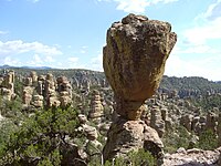
Chiricahua National Monument is a unit of the National Park Service. The monument is located approximately 36 miles southeast of Willcox, Arizona. It preserves the remains of an immense volcanic eruption that shook the region some 27 million years ago. Called the Turkey Creek Caldera eruption, it eventually laid down two thousand feet of ash and pumice, highly silicious in nature. This eventually hardened into rhyolitic tuff, (See: Tuff), and eroded into the natural features visible at the monument today.
The national monument also preserves the Faraway Ranch, owned at one time by Swedish immigrants Neil and Emma Erickson.


