Chokhatauri Municipality
Appearance
Chokatauri Municipality
ჩოხატაურის მუნიციპალიტეტი | |
|---|---|
 Chokatauri Municipality | |
| Country | |
| Mkhare | Guria |
| Area | |
| • Total | 825.1 km2 (318.6 sq mi) |
| Population (2014) | |
| • Total | 19,001 |
| Time zone | UTC+4 (Georgian Time) |
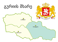
Chokhatauri (Georgian: ჩოხატაურის მუნიციპალიტეტი) is a district of Georgia, in the region of Guria. Its largest city and administrative centre is Chokhatauri.
Villages in the district
Villages in the Chokhatauri district include:
- Bukistsikhe
- Chaisubani
- Chokhatauri
- Dablatsikhe
- Didivani
- Erketi
- Ganakhleba
- Gogolesubani
- Goraberezhouli
- Guturi
- Khevi
- Khidistavi
- Kokhnari
- Kvenobani
- Nabeghlavi
- Partskhma
- Sachamiaseri
- Shuaganakhleba
- Shuasurebi
- Vazimleti
- Zemokheti
- Zemosurebi
- Zoti
- Janeuli
See also
External links
- Districts of Georgia, Statoids.com
- chokhautari.ge - Chokhatauri Municipality's official web site


