
Chop–Tysa
| Cho –Tysa | |
|---|---|
 Click on the map for a fullscreen view | |
| Location | |
| Country | Ukraine |
| Location | Solomonovo, Uzhhorod Raion, Zakarpattia Oblast |
| Coordinates | 48°25′06″N 22°10′13″E / 48.418431°N 22.170222°E |
| Details | |
| Hours | Open 24 Hours |
Chop–Tysa[1] is a land border crossing between Ukraine and Hungary on the Ukrainian side, near the village of Solomonovo, Uzhhorod Raion, Zakarpattia Oblast.
The crossing is situated on Highway M06. Across the border on the Hungarian side is the town of Zahony, Szabolcs-Szatmár-Bereg County, Northern Great Plain.
The type of crossing is automobile. The types of transportation for automobile crossings are passenger and freight. Pedestrian and bicycle movement is closed.[2]
The port of entry is part of the Tysa customs post of Chop customs.
-
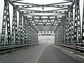 Bridge over Tysa viewing the Hungarian side

See also
References
- ^ Reforms of the Border Management System. Eastern Partnership Civil Society Forum
- ^ List of border crossing points
External links
- State Border Guard of Ukraine website
- General information from The State Border Service website
This article about a location in Ukraine is a stub. You can help Wikipedia by expanding it. |