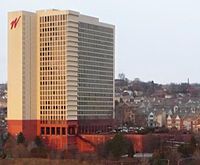
City View (Pittsburgh)
| City View | |
|---|---|
 | |
 | |
| General information | |
| Type | Residential |
| Location | 1420 Centre Avenue |
| Town or city | Pittsburgh |
| Country | United States of America |
| Coordinates | 40°26′26″N 79°59′11″W / 40.44056°N 79.98639°W |
| Construction started | 1958 |
| Completed | 1964 |
| Height | 300 ft (91 m) |
| Technical details | |
| Floor count | 24 |
| Design and construction | |
| Architect(s) | I. M. Pei |
City View is a 300 ft (91m) highrise in Pittsburgh, Pennsylvania. It was completed in 1964 and has 24 floors. It is tied with the Commonwealth Building and The Carlyle for the 26th tallest building in Pittsburgh. It was designed by I.M. Pei.[1] From its inception in 1964 until 2014 it was known as "Washington Plaza".
See also
References
Wikimedia Commons has media related to Washington Plaza.
This article includes a list of general references, but it lacks sufficient corresponding inline citations. (July 2008) |
This article needs additional citations for verification. (July 2008) |
External links

