Clayton Center, Iowa
Clayton Center, Iowa | |
|---|---|
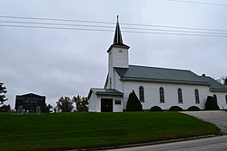
 Zion Lutheran Church in Clayton Center | |
| Coordinates: 42°53′00″N 91°19′36″W / 42.88333°N 91.32667°W | |
| Country | United States |
| State | Iowa |
| County | Clayton |
| Elevation | 988 ft (301 m) |
| Time zone | UTC-6 (Central (CST)) |
| • Summer (DST) | UTC-5 (CDT) |
| Area code | 563 |
| GNIS feature ID | 455451 |
Clayton Center is an unincorporated community located in Clayton County, Iowa. The area was settled by a German colony about five miles east of Elkader. In April 1856, the land was surveyed by Lewis Brockman, who established the location as the, "southeast quarter of section 8, township 93 north, range 3 west."[1] Clayton Center was then platted June 27, 1857 by Fred Hartmann.[2]
References
Wikimedia Commons has media related to Clayton Center, Iowa.
- ^ History of Clayton County 1882, Chapter XXXVIII: Read Township, page 1072-1073.
- ^ History of Clayton County, Iowa Volume 1, pages 107, 322, 492.


