
Coal Valley, Alabama
Coal Valley, Alabama | |
|---|---|
 Coal Valley, Alabama  Coal Valley, Alabama | |
| Coordinates: 33°44′24″N 87°25′05″W / 33.74000°N 87.41806°W | |
| Country | United States |
| State | Alabama |
| County | Walker |
| Elevation | 367 ft (112 m) |
| Time zone | UTC-6 (Central (CST)) |
| • Summer (DST) | UTC-5 (CDT) |
| Area code | 205 |
| GNIS feature ID | 116306[1] |
Coal Valley, also known as Cormick, is an unincorporated community in Walker County, Alabama, United States.
History
Coal Valley is named for the abundance of coal in the surrounding area.[2] Coal mines were opened in Coal Valley after the completion of the Georgia Pacific Railway.[3] The Coal Valley mines played a role in the 1920 Alabama coal strike.[4] A post office operated under the name Cormick from 1890 to 1891 and under the name Coal Valley from 1891 to 1951.[5]
Notes
- ^ "Coal Valley". Geographic Names Information System. United States Geological Survey, United States Department of the Interior.
- ^ Foscue, Virginia (1989). Place Names in Alabama. Tuscaloosa: The University of Alabama Press. p. 37. ISBN 0-8173-0410-X.
- ^ Armes, Ethel (1972). The Story of Coal and Iron in Alabama. Birmingham: The Book-Keepers Press. p. 502.
- ^ Brian Kelly (2001). Race, Class, and Power in the Alabama Coalfields, 1908-21. University of Illinois Press. p. 172. ISBN 978-0-252-06933-8.
- ^ "Walker County". Jim Forte Postal History. Retrieved 30 November 2015.
External links
Municipalities and communities of Walker County, Alabama, United States | ||
|---|---|---|
| Cities | 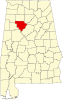 | |
| Towns | ||
| Unincorporated communities | ||
| Footnotes | ‡This populated place also has portions in an adjacent county or counties | |
This Alabama state location article is a stub. You can help Wikipedia by expanding it. |