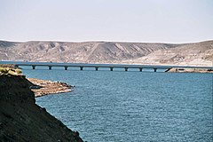
Collón Curá River
Appearance
| Collón Curá River | |
|---|---|
 | |
| Physical characteristics | |
| Source | |
| • elevation | 970 m (3,180 ft) |
| Length | 70 km (43 mi) |
The Collón Curá River is a geographical feature of Neuquén Province, Argentina. It flows southward from the confluence of the Aluminé and Chimehuin Rivers, near the town of Junín de los Andes, for around 70 km (44 mi), past which it becomes a tributary of the Limay River.
The valley is famous for its two activities: Birdwatching and Fly fishing.
See also
References
- Rand McNally, The New International Atlas, 1993.
- GEOnet Names Server
39°57′48″S 71°04′32″W / 39.96333°S 71.07556°W
